Quma geodata
Quma (Chongqing) is a seat of a fourth-order administrative division; located in China in Asia/Shanghai (GMT+8) time zone. In our database, there are 1268 cities with bigger population. Compared to other cities in China, 55.8% of cities are located further ↓South; 78.1% of cities are located further →East and 66.6% of cities have lower elevation than Quma. Note1


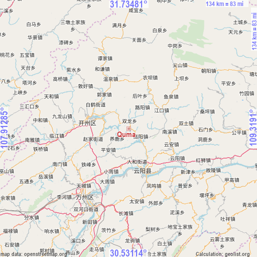
Quma GPS coordinates[2]
31° 8' 5.568" North, 108° 36' 57.492" East
| Map corner | latitude | longitude |
|---|---|---|
| Upper-left | 31.73481°, | 107.91285° |
| Center: | 31.13488°, | 108.61597° |
| Lower-right: | 30.53114°, | 109.3191° |
| Map W x H: | 133.8×133.8 km | = 83.1×83.1mi |
| max Lat: | 53.31946° ⇑44.2% North |
| Quma: | 31.13488° |
| min Lat: | ⇓55.8% South 18.22056° |
| min Long | Quma | max Long |
| 75.07348° | 108.61597° | 134.28917° |
| W 21.9%⇐ | ⇒78.1% E |
Elevation
Elevation of Quma is 353 m = 1158 ft, and this is 131.8 m = 432 ft below average elevation for this country.
| Max E: |
5622 m = 18445 ft | 33.4% |
| Avg. | 484.8 m = 1591 ft | |
| Quma | 353 m = 1158 ft | |
Min E: |
-3 m = -10 ft | 66.6% |
See also: China elevation on elevation.city.
Geographical zone
Quma is located in North temperate zone (between Tropic of Cancer and the Arctic Circle). Distance of this Northern Tropic circle is 856 km =531.9 mi to South.| Distance of | km | miles | from Quma |
|---|---|---|---|
| North Pole | 6545.2 | 4067 | to North |
| Arctic Circle | 3939.3 | 2447.8 | to North |
| Tropic Cancer | 856 | 531.9 | to South |
| Equator | 3461.9 | 2151.1 | to South |


Nearby cities:
15 places around Quma: (largest is in red/bold)
• Baiqiao
16.5 km =10.3 mi,  352°
352°
• Fengle
20.1 km =12.5 mi,  287°
287°
• Gaoyang
7.2 km =4.5 mi,  123°
123°
• Houba
13 km =8.1 mi,  306°
306°
• Houye
18.1 km =11.2 mi,  18°
18°
• Huangshi
17.9 km =11.1 mi,  146°
146°
• Jiangkou
19.5 km =12.1 mi,  60°
60°
• Jinfeng
8.3 km =5.2 mi,  321°
321°
• Luyang
13.3 km =8.3 mi,  31°
31°
• Ping’an
15.4 km =9.6 mi,  224°
224°
• Qukou
13 km =8.1 mi,  271°
271°
• Renhe
17.3 km =10.7 mi,  165°
165°
• Shuanglong
4.1 km =2.5 mi,  4°
4°
• Shuikou
20.1 km =12.5 mi,  135°
135°
• Yanglu
7.9 km =4.9 mi,  230°
230°
Sources, notices
• [Note1] Compared only with cities in China existing in our database
• [Src1] Map data: © OpenStreetMap contributors (CC-BY-SA)
• [Src2] Other city data from geonames.org with taken over terms of usage.
• [Src3] Geographical zone / Annual Mean Temperature by Robert A. Rohde @ Wikipedia
