Huangshi geodata
Huangshi (Chongqing) is a seat of a fourth-order administrative division; located in China in Asia/Shanghai (GMT+8) time zone. In our database, there are 1268 cities with bigger population. Compared to other cities in China, 54.9% of cities are located further ↓South; 77.6% of cities are located further →East and 53.4% of cities have lower elevation than Huangshi. Note1


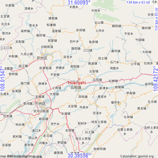
Huangshi GPS coordinates[2]
31° 0' 0.54" North, 108° 43' 6.924" East
| Map corner | latitude | longitude |
|---|---|---|
| Upper-left | 31.60093°, | 108.01547° |
| Center: | 31.00015°, | 108.71859° |
| Lower-right: | 30.39556°, | 109.42172° |
| Map W x H: | 134×134 km | = 83.3×83.3mi |
| max Lat: | 53.31946° ⇑45.1% North |
| Huangshi: | 31.00015° |
| min Lat: | ⇓54.9% South 18.22056° |
| min Long | Huangshi | max Long |
| 75.07348° | 108.71859° | 134.28917° |
| W 22.4%⇐ | ⇒77.6% E |
Elevation
Elevation of Huangshi is 192 m = 630 ft, and this is 292.8 m = 961 ft below average elevation for this country.
| Max E: |
5622 m = 18445 ft | 46.6% |
| Avg. | 484.8 m = 1591 ft | |
| Huangshi | 192 m = 630 ft | |
Min E: |
-3 m = -10 ft | 53.4% |
See also: China elevation on elevation.city.
Geographical zone
Huangshi is located in North temperate zone (between Tropic of Cancer and the Arctic Circle). Distance of this Northern Tropic circle is 841 km =522.6 mi to South.| Distance of | km | miles | from Huangshi |
|---|---|---|---|
| North Pole | 6560.2 | 4076.3 | to North |
| Arctic Circle | 3954.3 | 2457.1 | to North |
| Tropic Cancer | 841 | 522.6 | to South |
| Equator | 3446.9 | 2141.8 | to South |


Nearby cities:
15 places around Huangshi: (largest is in red/bold)
• Baoping
18.1 km =11.2 mi,  135°
135°
• Bayang
14.5 km =9 mi,  239°
239°
• Fengwu
14.7 km =9.1 mi,  168°
168°
• Gaoyang
11.7 km =7.3 mi,  341°
341°
• Huangbo
16.2 km =10.1 mi,  233°
233°
• Nanxi
16.9 km =10.5 mi,  41°
41°
• Panlong
10.4 km =6.5 mi,  184°
184°
• Qinglong
7.7 km =4.8 mi,  195°
195°
• Quma
17.9 km =11.1 mi,  326°
326°
• Renhe
5.8 km =3.6 mi,  252°
252°
• Shuangjiang
7.3 km =4.5 mi,  208°
208°
• Shuikou
4.4 km =2.7 mi,  81°
81°
• Yanglu
18.7 km =11.6 mi,  302°
302°
• Yunyang
15.5 km =9.6 mi,  90°
90°
• Yun’an
13.8 km =8.6 mi,  68°
68°
Sources, notices
• [Note1] Compared only with cities in China existing in our database
• [Src1] Map data: © OpenStreetMap contributors (CC-BY-SA)
• [Src2] Other city data from geonames.org with taken over terms of usage.
• [Src3] Geographical zone / Annual Mean Temperature by Robert A. Rohde @ Wikipedia
