Zhuxi geodata
Zhuxi (Chongqing) is a seat of a fourth-order administrative division; located in China in Asia/Shanghai (GMT+8) time zone. In our database, there are 1268 cities with bigger population. Compared to other cities in China, 55.7% of cities are located further ↓South; 79.5% of cities are located further →East and 52.3% of cities have lower elevation than Zhuxi. Note1


Zhuxi GPS coordinates[2]
31° 7' 27.948" North, 108° 17' 26.34" East
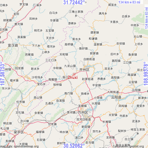
| Map corner | latitude | longitude |
|---|---|---|
| Upper-left | 31.72442°, | 107.58753° |
| Center: | 31.12443°, | 108.29065° |
| Lower-right: | 30.52062°, | 108.99378° |
| Map W x H: | 133.9×133.9 km | = 83.2×83.2mi |
| max Lat: | 53.31946° ⇑44.3% North |
| Zhuxi: | 31.12443° |
| min Lat: | ⇓55.7% South 18.22056° |
| min Long | Zhuxi | max Long |
| 75.07348° | 108.29065° | 134.28917° |
| W 20.5%⇐ | ⇒79.5% E |
Elevation
Elevation of Zhuxi is 183 m = 600 ft, and this is 301.8 m = 990 ft below average elevation for this country.
| Max E: |
5622 m = 18445 ft | 47.7% |
| Avg. | 484.8 m = 1591 ft | |
| Zhuxi | 183 m = 600 ft | |
Min E: |
-3 m = -10 ft | 52.3% |
See also: China elevation on elevation.city.
Geographical zone
Zhuxi is located in North temperate zone (between Tropic of Cancer and the Arctic Circle). Distance of this Northern Tropic circle is 854.8 km =531.1 mi to South.| Distance of | km | miles | from Zhuxi |
|---|---|---|---|
| North Pole | 6546.3 | 4067.7 | to North |
| Arctic Circle | 3940.5 | 2448.5 | to North |
| Tropic Cancer | 854.8 | 531.1 | to South |
| Equator | 3460.7 | 2150.4 | to South |


Nearby cities:
15 places around Zhuxi: (largest is in red/bold)
• Changsha
13.9 km =8.6 mi,  174°
174°
• Dade
10.9 km =6.8 mi,  25°
25°
• Fengle
13.9 km =8.6 mi,  58°
58°
• Hanfeng
11.8 km =7.3 mi, 64°
• Jiulongshan
8.7 km =5.4 mi,  334°
334°
• Linjiang
7.3 km =4.5 mi,  247°
247°
• Nanmen
18.6 km =11.6 mi,  194°
194°
• Nanya
19.9 km =12.4 mi,  257°
257°
• Qukou
18 km =11.2 mi,  85°
85°
• Tiefeng
20.1 km =12.5 mi,  150°
150°
• Tieqiao
17.7 km =11 mi,  237°
237°
• Zhaojia
12.5 km =7.8 mi,  112°
112°
• Zhendong
12 km =7.5 mi, 55°
• Zhen’an
4 km =2.5 mi,  38°
38°
• Zhonghe
16.2 km =10.1 mi,  290°
290°
Sources, notices
• [Note1] Compared only with cities in China existing in our database
• [Src1] Map data: © OpenStreetMap contributors (CC-BY-SA)
• [Src2] Other city data from geonames.org with taken over terms of usage.
• [Src3] Geographical zone / Annual Mean Temperature by Robert A. Rohde @ Wikipedia
