Changsha geodata
Changsha (Chongqing) is a seat of a fourth-order administrative division; located in China in Asia/Shanghai (GMT+8) time zone. In our database, there are 1268 cities with bigger population. Compared to other cities in China, 54.8% of cities are located further ↓South; 79.4% of cities are located further →East and 53.2% of cities have lower elevation than Changsha. Note1


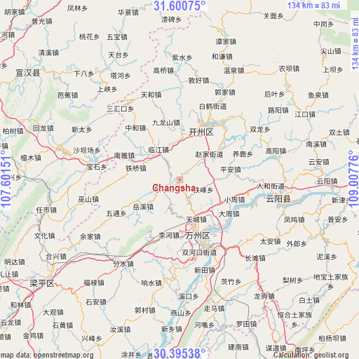
Changsha GPS coordinates[2]
30° 59' 59.892" North, 108° 18' 16.668" East
| Map corner | latitude | longitude |
|---|---|---|
| Upper-left | 31.60075°, | 107.60151° |
| Center: | 30.99997°, | 108.30463° |
| Lower-right: | 30.39538°, | 109.00776° |
| Map W x H: | 134×134 km | = 83.3×83.3mi |
| max Lat: | 53.31946° ⇑45.2% North |
| Changsha: | 30.99997° |
| min Lat: | ⇓54.8% South 18.22056° |
| min Long | Changsha | max Long |
| 75.07348° | 108.30463° | 134.28917° |
| W 20.6%⇐ | ⇒79.4% E |
Elevation
Elevation of Changsha is 190 m = 623 ft, and this is 294.8 m = 967 ft below average elevation for this country.
| Max E: |
5622 m = 18445 ft | 46.8% |
| Avg. | 484.8 m = 1591 ft | |
| Changsha | 190 m = 623 ft | |
Min E: |
-3 m = -10 ft | 53.2% |
See also: China elevation on elevation.city.
Geographical zone
Changsha is located in North temperate zone (between Tropic of Cancer and the Arctic Circle). Distance of this Northern Tropic circle is 841 km =522.6 mi to South.| Distance of | km | miles | from Changsha |
|---|---|---|---|
| North Pole | 6560.2 | 4076.3 | to North |
| Arctic Circle | 3954.3 | 2457.1 | to North |
| Tropic Cancer | 841 | 522.6 | to South |
| Equator | 3446.9 | 2141.8 | to South |


Nearby cities:
15 places around Changsha: (largest is in red/bold)
• Gaoliang
19.6 km =12.2 mi,  180°
180°
• Lihe
20.8 km =12.9 mi,  191°
191°
• Linjiang
13.7 km =8.5 mi,  323°
323°
• Nanmen
7.2 km =4.5 mi,  234°
234°
• Ping’an
19.3 km =12 mi,  78°
78°
• Taibai
20.1 km =12.5 mi,  165°
165°
• Tiancheng
16 km =9.9 mi,  157°
157°
• Tiefeng
9.4 km =5.8 mi,  112°
112°
• Tieqiao
16.9 km =10.5 mi,  285°
285°
• Xiongjia
16.5 km =10.3 mi,  131°
131°
• Yuexi
17 km =10.6 mi, 234°
• Zhaojia
13.6 km =8.5 mi,  48°
48°
• Zhen’an
17 km =10.6 mi,  3°
3°
• Zhoujiaba
18.4 km =11.4 mi, 161°
• Zhuxi
13.9 km =8.6 mi,  354°
354°
Sources, notices
• [Note1] Compared only with cities in China existing in our database
• [Src1] Map data: © OpenStreetMap contributors (CC-BY-SA)
• [Src2] Other city data from geonames.org with taken over terms of usage.
• [Src3] Geographical zone / Annual Mean Temperature by Robert A. Rohde @ Wikipedia
