Huangjin geodata
Huangjin (Chongqing) is a seat of a fourth-order administrative division; located in China in Asia/Shanghai (GMT+8) time zone. In our database, there are 1268 cities with bigger population. Compared to other cities in China, 50.5% of cities are located further ↑North; 80.5% of cities are located further →East and 52.9% of cities have lower elevation than Huangjin. Note1


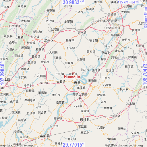
Huangjin GPS coordinates[2]
30° 22' 42.996" North, 108° 0' 5.76" East
| Map corner | latitude | longitude |
|---|---|---|
| Upper-left | 30.98331°, | 107.29848° |
| Center: | 30.37861°, | 108.0016° |
| Lower-right: | 29.77015°, | 108.70473° |
| Map W x H: | 134.9×134.9 km | = 83.8×83.8mi |
| max Lat: | 53.31946° ⇑50.5% North |
| Huangjin: | 30.37861° |
| min Lat: | ⇓49.5% South 18.22056° |
| min Long | Huangjin | max Long |
| 75.07348° | 108.0016° | 134.28917° |
| W 19.5%⇐ | ⇒80.5% E |
Elevation
Elevation of Huangjin is 188 m = 617 ft, and this is 296.8 m = 974 ft below average elevation for this country.
| Max E: |
5622 m = 18445 ft | 47.1% |
| Avg. | 484.8 m = 1591 ft | |
| Huangjin | 188 m = 617 ft | |
Min E: |
-3 m = -10 ft | 52.9% |
See also: China elevation on elevation.city.
Geographical zone
Huangjin is located in North temperate zone (between Tropic of Cancer and the Arctic Circle). Distance of this Northern Tropic circle is 771.9 km =479.6 mi to South.| Distance of | km | miles | from Huangjin |
|---|---|---|---|
| North Pole | 6629.3 | 4119.3 | to North |
| Arctic Circle | 4023.4 | 2500 | to North |
| Tropic Cancer | 771.9 | 479.6 | to South |
| Equator | 3377.8 | 2098.9 | to South |


Nearby cities:
15 places around Huangjin: (largest is in red/bold)
• Baishi
13.3 km =8.3 mi,  238°
238°
• Dongxi
13.5 km =8.4 mi,  151°
151°
• Guanba
16.8 km =10.4 mi,  316°
316°
• Jinsheng
16.4 km =10.2 mi,  355°
355°
• Lichang
13.8 km =8.6 mi,  103°
103°
• Ruxi
14.9 km =9.3 mi,  26°
26°
• Sanhui
12.7 km =7.9 mi,  270°
270°
• Shibao
19 km =11.8 mi,  74°
74°
• Tujing
11.5 km =7.1 mi, 70°
• Wangchang
18.3 km =11.4 mi,  109°
109°
• Xingfeng
11 km =6.8 mi,  331°
331°
• Yanxi
15.1 km =9.4 mi,  127°
127°
• Yongfeng
18.7 km =11.6 mi,  249°
249°
• Zhongzhou
9.9 km =6.2 mi,  162°
162°
• Zizhao
18.2 km =11.3 mi,  340°
340°
Sources, notices
• [Note1] Compared only with cities in China existing in our database
• [Src1] Map data: © OpenStreetMap contributors (CC-BY-SA)
• [Src2] Other city data from geonames.org with taken over terms of usage.
• [Src3] Geographical zone / Annual Mean Temperature by Robert A. Rohde @ Wikipedia
