Baishi geodata
Baishi (Chongqing) is a seat of a fourth-order administrative division; located in China in Asia/Shanghai (GMT+8) time zone. In our database, there are 1268 cities with bigger population. Compared to other cities in China, 51% of cities are located further ↑North; 81% of cities are located further →East and 63.3% of cities have lower elevation than Baishi. Note1


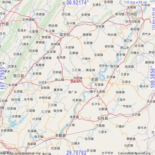
Baishi GPS coordinates[2]
30° 18' 59.976" North, 107° 52' 56.892" East
| Map corner | latitude | longitude |
|---|---|---|
| Upper-left | 30.92174°, | 107.17935° |
| Center: | 30.31666°, | 107.88247° |
| Lower-right: | 29.70782°, | 108.5856° |
| Map W x H: | 135×135 km | = 83.9×83.9mi |
| max Lat: | 53.31946° ⇑51% North |
| Baishi: | 30.31666° |
| min Lat: | ⇓49% South 18.22056° |
| min Long | Baishi | max Long |
| 75.07348° | 107.88247° | 134.28917° |
| W 19%⇐ | ⇒81% E |
Elevation
Elevation of Baishi is 302 m = 991 ft, and this is 182.8 m = 600 ft below average elevation for this country.
| Max E: |
5622 m = 18445 ft | 36.7% |
| Avg. | 484.8 m = 1591 ft | |
| Baishi | 302 m = 991 ft | |
Min E: |
-3 m = -10 ft | 63.3% |
See also: China elevation on elevation.city.
Geographical zone
Baishi is located in North temperate zone (between Tropic of Cancer and the Arctic Circle). Distance of this Northern Tropic circle is 765 km =475.3 mi to South.| Distance of | km | miles | from Baishi |
|---|---|---|---|
| North Pole | 6636.2 | 4123.5 | to North |
| Arctic Circle | 4030.3 | 2504.3 | to North |
| Tropic Cancer | 765 | 475.3 | to South |
| Equator | 3370.9 | 2094.6 | to South |


Nearby cities:
15 places around Baishi: (largest is in red/bold)
• Bashan
14.4 km =8.9 mi,  269°
269°
• Dongxi
18.5 km =11.5 mi,  105°
105°
• Guanba
19.1 km =11.9 mi,  359°
359°
• Huangjin
13.3 km =8.3 mi,  58°
58°
• Huaqiao
18.7 km =11.6 mi,  285°
285°
• Maguan
16.4 km =10.2 mi,  301°
301°
• Qinglong
19.1 km =11.9 mi,  209°
209°
• Renjia
19.3 km =12 mi,  182°
182°
• Sanhui
7.2 km =4.5 mi,  349°
349°
• Shanguang
12.9 km =8 mi,  199°
199°
• Wuyang
16.7 km =10.4 mi,  138°
138°
• Xingfeng
17.6 km =10.9 mi,  20°
20°
• Xinsheng
13.3 km =8.3 mi,  152°
152°
• Yongfeng
6.1 km =3.8 mi, 271°
• Zhongzhou
14.7 km =9.1 mi,  99°
99°
Sources, notices
• [Note1] Compared only with cities in China existing in our database
• [Src1] Map data: © OpenStreetMap contributors (CC-BY-SA)
• [Src2] Other city data from geonames.org with taken over terms of usage.
• [Src3] Geographical zone / Annual Mean Temperature by Robert A. Rohde @ Wikipedia
