Yangdu geodata
Yangdu (Chongqing) is a seat of a fourth-order administrative division; located in China in Asia/Shanghai (GMT+8) time zone. In our database, there are 1268 cities with bigger population. Compared to other cities in China, 52.7% of cities are located further ↑North; 80.8% of cities are located further →East and 55.8% of cities have lower elevation than Yangdu. Note1


Yangdu GPS coordinates[2]
30° 7' 46.776" North, 107° 55' 41.304" East
| Map corner | latitude | longitude |
|---|---|---|
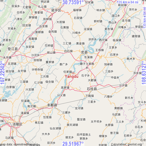
| Upper-left | 30.73591°, | 107.22502° |
| Center: | 30.12966°, | 107.92814° |
| Lower-right: | 29.51967°, | 108.63127° |
| Map W x H: | 135.2×135.2 km | = 84×84mi |
| max Lat: | 53.31946° ⇑52.7% North |
| Yangdu: | 30.12966° |
| min Lat: | ⇓47.3% South 18.22056° |
| min Long | Yangdu | max Long |
| 75.07348° | 107.92814° | 134.28917° |
| W 19.2%⇐ | ⇒80.8% E |
Elevation
Elevation of Yangdu is 214 m = 702 ft, and this is 270.8 m = 888 ft below average elevation for this country.
| Max E: |
5622 m = 18445 ft | 44.2% |
| Avg. | 484.8 m = 1591 ft | |
| Yangdu | 214 m = 702 ft | |
Min E: |
-3 m = -10 ft | 55.8% |
See also: China elevation on elevation.city.
Geographical zone
Yangdu is located in North temperate zone (between Tropic of Cancer and the Arctic Circle). Distance of this Northern Tropic circle is 744.2 km =462.4 mi to South.| Distance of | km | miles | from Yangdu |
|---|---|---|---|
| North Pole | 6657 | 4136.5 | to North |
| Arctic Circle | 4051.1 | 2517.2 | to North |
| Tropic Cancer | 744.2 | 462.4 | to South |
| Equator | 3350.1 | 2081.7 | to South |


Nearby cities:
15 places around Yangdu: (largest is in red/bold)
• Baishi
21.3 km =13.2 mi,  348°
348°
• Daxie
18.6 km =11.6 mi,  109°
109°
• Dongxi
20.7 km =12.9 mi,  40°
40°
• Gaojia
13.8 km =8.6 mi,  208°
208°
• Longkong
9.5 km =5.9 mi,  187°
187°
• Mozi
14.7 km =9.1 mi,  61°
61°
• Qinglong
14.4 km =8.9 mi,  286°
286°
• Renjia
5.4 km =3.4 mi, 285°
• Shanguang
12.2 km =7.6 mi,  315°
315°
• Shizhi
15.4 km =9.6 mi,  236°
236°
• Shizi
11.8 km =7.3 mi,  99°
99°
• Shuanglongchang
19.9 km =12.4 mi,  270°
270°
• Wuyang
10.6 km =6.6 mi, 38°
• Xinsheng
9.1 km =5.7 mi,  10°
10°
• Zhongzhou
20.9 km =13 mi,  28°
28°
Sources, notices
• [Note1] Compared only with cities in China existing in our database
• [Src1] Map data: © OpenStreetMap contributors (CC-BY-SA)
• [Src2] Other city data from geonames.org with taken over terms of usage.
• [Src3] Geographical zone / Annual Mean Temperature by Robert A. Rohde @ Wikipedia
