Baijia geodata
Baijia (Chongqing) is a seat of a fourth-order administrative division; located in China in Asia/Shanghai (GMT+8) time zone. In our database, there are 1268 cities with bigger population. Compared to other cities in China, 53.8% of cities are located further ↑North; 82.7% of cities are located further →East and 74.8% of cities have lower elevation than Baijia. Note1


Baijia GPS coordinates[2]
30° 1' 1.344" North, 107° 19' 32.736" East
| Map corner | latitude | longitude |
|---|---|---|
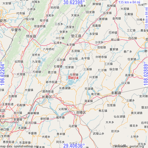
| Upper-left | 30.62398°, | 106.62264° |
| Center: | 30.01704°, | 107.32576° |
| Lower-right: | 29.40636°, | 108.02889° |
| Map W x H: | 135.4×135.4 km | = 84.1×84.1mi |
| max Lat: | 53.31946° ⇑53.8% North |
| Baijia: | 30.01704° |
| min Lat: | ⇓46.2% South 18.22056° |
| min Long | Baijia | max Long |
| 75.07348° | 107.32576° | 134.28917° |
| W 17.3%⇐ | ⇒82.7% E |
Elevation
Elevation of Baijia is 518 m = 1699 ft, and this is 33.2 m = 109 ft above average elevation for this country.
| Max E: |
5622 m = 18445 ft | 25.2% |
| Baijia | 518 m 1699 ft | |
| Avg. | 484.8 m = 1591 ft | |
Min E: |
-3 m = -10 ft | 74.8% |
See also: China elevation on elevation.city.
Geographical zone
Baijia is located in North temperate zone (between Tropic of Cancer and the Arctic Circle). Distance of this Northern Tropic circle is 731.7 km =454.7 mi to South.| Distance of | km | miles | from Baijia |
|---|---|---|---|
| North Pole | 6669.5 | 4144.2 | to North |
| Arctic Circle | 4063.6 | 2525 | to North |
| Tropic Cancer | 731.7 | 454.7 | to South |
| Equator | 3337.6 | 2073.9 | to South |


Nearby cities:
15 places around Baijia: (largest is in red/bold)
• Baojia
7.8 km =4.8 mi,  328°
328°
• Changshouhu
15 km =9.3 mi,  214°
214°
• Chongxing
17.8 km =11.1 mi,  97°
97°
• Conglin
16.5 km =10.3 mi,  173°
173°
• Heyou
7.7 km =4.8 mi,  18°
18°
• Linfeng
17.3 km =10.7 mi,  216°
216°
• Longhe
14 km =8.7 mi,  270°
270°
• Pingshan
13 km =8.1 mi,  47°
47°
• Sanxi
13.4 km =8.3 mi,  67°
67°
• Shiyan
16.5 km =10.3 mi,  296°
296°
• Shuanglong
13.4 km =8.3 mi,  241°
241°
• Yantai
14.4 km =8.9 mi,  357°
357°
• Yunji
10.9 km =6.8 mi, 172°
• Yuntai
17.9 km =11.1 mi,  319°
319°
• Zhenxi
18.7 km =11.6 mi,  134°
134°
Sources, notices
• [Note1] Compared only with cities in China existing in our database
• [Src1] Map data: © OpenStreetMap contributors (CC-BY-SA)
• [Src2] Other city data from geonames.org with taken over terms of usage.
• [Src3] Geographical zone / Annual Mean Temperature by Robert A. Rohde @ Wikipedia
