Shiyan geodata
Shiyan (Chongqing) is a seat of a fourth-order administrative division; located in China in Asia/Shanghai (GMT+8) time zone. In our database, there are 1268 cities with bigger population. Compared to other cities in China, 53.1% of cities are located further ↑North; 83.2% of cities are located further →East and 69.2% of cities have lower elevation than Shiyan. Note1


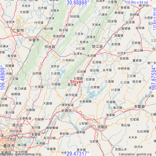
Shiyan GPS coordinates[2]
30° 5' 0.42" North, 107° 10' 19.956" East
| Map corner | latitude | longitude |
|---|---|---|
| Upper-left | 30.68998°, | 106.46909° |
| Center: | 30.08345°, | 107.17221° |
| Lower-right: | 29.47317°, | 107.87534° |
| Map W x H: | 135.3×135.3 km | = 84.1×84.1mi |
| max Lat: | 53.31946° ⇑53.1% North |
| Shiyan: | 30.08345° |
| min Lat: | ⇓46.9% South 18.22056° |
| min Long | Shiyan | max Long |
| 75.07348° | 107.17221° | 134.28917° |
| W 16.8%⇐ | ⇒83.2% E |
Elevation
Elevation of Shiyan is 396 m = 1299 ft, and this is 88.8 m = 291 ft below average elevation for this country.
| Max E: |
5622 m = 18445 ft | 30.8% |
| Avg. | 484.8 m = 1591 ft | |
| Shiyan | 396 m = 1299 ft | |
Min E: |
-3 m = -10 ft | 69.2% |
See also: China elevation on elevation.city.
Geographical zone
Shiyan is located in North temperate zone (between Tropic of Cancer and the Arctic Circle). Distance of this Northern Tropic circle is 739 km =459.2 mi to South.| Distance of | km | miles | from Shiyan |
|---|---|---|---|
| North Pole | 6662.1 | 4139.6 | to North |
| Arctic Circle | 4056.2 | 2520.4 | to North |
| Tropic Cancer | 739 | 459.2 | to South |
| Equator | 3345 | 2078.5 | to South |


Nearby cities:
15 places around Shiyan: (largest is in red/bold)
• Baijia
16.5 km =10.3 mi,  116°
116°
• Baojia
10.8 km =6.7 mi,  93°
93°
• Changshouhu
20.8 km =12.9 mi,  162°
162°
• Chengxi
16.3 km =10.1 mi,  30°
30°
• Gelan
7.6 km =4.7 mi,  225°
225°
• Haitang
11.3 km =7 mi, 29°
• Heyou
17.3 km =10.7 mi, 90°
• Linfeng
21.9 km =13.6 mi,  167°
167°
• Longhe
7.4 km =4.6 mi, 173°
• Shuanglong
14.1 km =8.8 mi, 167°
• Wanshun
19.9 km =12.4 mi,  255°
255°
• Wudong
21.5 km =13.4 mi,  49°
49°
• Xinshi
15.2 km =9.4 mi,  205°
205°
• Yantai
15.8 km =9.8 mi,  63°
63°
• Yuntai
6.9 km =4.3 mi, 26°
Sources, notices
• [Note1] Compared only with cities in China existing in our database
• [Src1] Map data: © OpenStreetMap contributors (CC-BY-SA)
• [Src2] Other city data from geonames.org with taken over terms of usage.
• [Src3] Geographical zone / Annual Mean Temperature by Robert A. Rohde @ Wikipedia
