Zhenxi geodata
Zhenxi (Chongqing) is a seat of a fourth-order administrative division; located in China in Asia/Shanghai (GMT+8) time zone. In our database, there are 1268 cities with bigger population. Compared to other cities in China, 55.1% of cities are located further ↑North; 82.3% of cities are located further →East and 52% of cities have lower elevation than Zhenxi. Note1


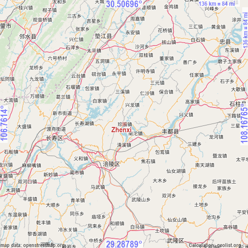
Zhenxi GPS coordinates[2]
29° 53' 57.444" North, 107° 27' 52.272" East
| Map corner | latitude | longitude |
|---|---|---|
| Upper-left | 30.50696°, | 106.7614° |
| Center: | 29.89929°, | 107.46452° |
| Lower-right: | 29.28789°, | 108.16765° |
| Map W x H: | 135.5×135.5 km | = 84.2×84.2mi |
| max Lat: | 53.31946° ⇑55.1% North |
| Zhenxi: | 29.89929° |
| min Lat: | ⇓44.9% South 18.22056° |
| min Long | Zhenxi | max Long |
| 75.07348° | 107.46452° | 134.28917° |
| W 17.7%⇐ | ⇒82.3% E |
Elevation
Elevation of Zhenxi is 181 m = 594 ft, and this is 303.8 m = 997 ft below average elevation for this country.
| Max E: |
5622 m = 18445 ft | 48% |
| Avg. | 484.8 m = 1591 ft | |
| Zhenxi | 181 m = 594 ft | |
Min E: |
-3 m = -10 ft | 52% |
See also: China elevation on elevation.city.
Geographical zone
Zhenxi is located in North temperate zone (between Tropic of Cancer and the Arctic Circle). Distance of this Northern Tropic circle is 718.6 km =446.5 mi to South.| Distance of | km | miles | from Zhenxi |
|---|---|---|---|
| North Pole | 6682.6 | 4152.4 | to North |
| Arctic Circle | 4076.7 | 2533.1 | to North |
| Tropic Cancer | 718.6 | 446.5 | to South |
| Equator | 3324.5 | 2065.7 | to South |


Nearby cities:
15 places around Zhenxi: (largest is in red/bold)
• Baijia
18.7 km =11.6 mi,  314°
314°
• Baisheng
11.8 km =7.3 mi,  216°
216°
• Chongxing
11.5 km =7.1 mi,  22°
22°
• Conglin
11.8 km =7.3 mi,  253°
253°
• Huwei
16.8 km =10.4 mi,  87°
87°
• Luoyun
18.4 km =11.4 mi,  135°
135°
• Nantuo
6.8 km =4.2 mi,  129°
129°
• Qingxi
11.2 km =7 mi,  183°
183°
• Rensha
21.2 km =13.2 mi,  36°
36°
• Renyi
12.4 km =7.7 mi,  97°
97°
• Sanxi
18.3 km =11.4 mi,  356°
356°
• Shetan
17.6 km =10.9 mi,  55°
55°
• Shilong
18.8 km =11.7 mi,  240°
240°
• Yunji
12.2 km =7.6 mi,  280°
280°
• Zhanpu
17.7 km =11 mi,  110°
110°
Sources, notices
• [Note1] Compared only with cities in China existing in our database
• [Src1] Map data: © OpenStreetMap contributors (CC-BY-SA)
• [Src2] Other city data from geonames.org with taken over terms of usage.
• [Src3] Geographical zone / Annual Mean Temperature by Robert A. Rohde @ Wikipedia
