Daguan geodata
Daguan (Chongqing) is a seat of a fourth-order administrative division; located in China in Asia/Shanghai (GMT+8) time zone. In our database, there are 1268 cities with bigger population. Compared to other cities in China, 50.8% of cities are located further ↓South; 81.2% of cities are located further →East and 69.8% of cities have lower elevation than Daguan. Note1


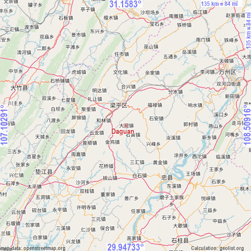
Daguan GPS coordinates[2]
30° 33' 16.92" North, 107° 48' 21.708" East
| Map corner | latitude | longitude |
|---|---|---|
| Upper-left | 31.1583°, | 107.10291° |
| Center: | 30.5547°, | 107.80603° |
| Lower-right: | 29.94733°, | 108.50916° |
| Map W x H: | 134.6×134.6 km | = 83.6×83.6mi |
| max Lat: | 53.31946° ⇑49.2% North |
| Daguan: | 30.5547° |
| min Lat: | ⇓50.8% South 18.22056° |
| min Long | Daguan | max Long |
| 75.07348° | 107.80603° | 134.28917° |
| W 18.8%⇐ | ⇒81.2% E |
Elevation
Elevation of Daguan is 407 m = 1335 ft, and this is 77.8 m = 255 ft below average elevation for this country.
| Max E: |
5622 m = 18445 ft | 30.2% |
| Avg. | 484.8 m = 1591 ft | |
| Daguan | 407 m = 1335 ft | |
Min E: |
-3 m = -10 ft | 69.8% |
See also: China elevation on elevation.city.
Geographical zone
Daguan is located in North temperate zone (between Tropic of Cancer and the Arctic Circle). Distance of this Northern Tropic circle is 791.4 km =491.8 mi to South.| Distance of | km | miles | from Daguan |
|---|---|---|---|
| North Pole | 6609.7 | 4107.1 | to North |
| Arctic Circle | 4003.8 | 2487.8 | to North |
| Tropic Cancer | 791.4 | 491.8 | to South |
| Equator | 3397.4 | 2111 | to South |


Nearby cities:
15 places around Daguan: (largest is in red/bold)
• Ansheng
17.1 km =10.6 mi,  331°
331°
• Baijia
10.3 km =6.4 mi,  65°
65°
• Chengbei
18.6 km =11.6 mi,  353°
353°
• Guanba
10.3 km =6.4 mi,  135°
135°
• Helin
12.4 km =7.7 mi,  283°
283°
• Jindai
11.6 km =7.2 mi,  296°
296°
• Jinji
11.2 km =7 mi,  219°
219°
• Jinsheng
17.8 km =11.1 mi,  100°
100°
• Panlong
9.9 km =6.2 mi,  25°
25°
• Renxian
17 km =10.6 mi,  314°
314°
• Shi’an
16.8 km =10.4 mi,  76°
76°
• Tiemen
10.8 km =6.7 mi,  237°
237°
• Xingfeng
16.7 km =10.4 mi,  126°
126°
• Yunlong
16.1 km =10 mi,  257°
257°
• Zizhao
12.9 km =8 mi, 101°
Sources, notices
• [Note1] Compared only with cities in China existing in our database
• [Src1] Map data: © OpenStreetMap contributors (CC-BY-SA)
• [Src2] Other city data from geonames.org with taken over terms of usage.
• [Src3] Geographical zone / Annual Mean Temperature by Robert A. Rohde @ Wikipedia
