Dongjia geodata
Dongjia (Chongqing) is a seat of a fourth-order administrative division; located in China in Asia/Shanghai (GMT+8) time zone. In our database, there are 1268 cities with bigger population. Compared to other cities in China, 51.9% of cities are located further ↑North; 81.5% of cities are located further →East and 71.7% of cities have lower elevation than Dongjia. Note1


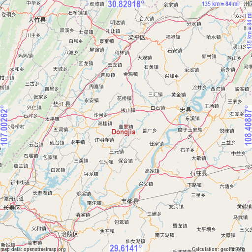
Dongjia GPS coordinates[2]
30° 13' 24.672" North, 107° 42' 20.664" East
| Map corner | latitude | longitude |
|---|---|---|
| Upper-left | 30.82918°, | 107.00262° |
| Center: | 30.22352°, | 107.70574° |
| Lower-right: | 29.6141°, | 108.40887° |
| Map W x H: | 135.1×135.1 km | = 83.9×83.9mi |
| max Lat: | 53.31946° ⇑51.9% North |
| Dongjia: | 30.22352° |
| min Lat: | ⇓48.1% South 18.22056° |
| min Long | Dongjia | max Long |
| 75.07348° | 107.70574° | 134.28917° |
| W 18.5%⇐ | ⇒81.5% E |
Elevation
Elevation of Dongjia is 447 m = 1467 ft, and this is 37.8 m = 124 ft below average elevation for this country.
| Max E: |
5622 m = 18445 ft | 28.3% |
| Avg. | 484.8 m = 1591 ft | |
| Dongjia | 447 m = 1467 ft | |
Min E: |
-3 m = -10 ft | 71.7% |
See also: China elevation on elevation.city.
Geographical zone
Dongjia is located in North temperate zone (between Tropic of Cancer and the Arctic Circle). Distance of this Northern Tropic circle is 754.6 km =468.9 mi to South.| Distance of | km | miles | from Dongjia |
|---|---|---|---|
| North Pole | 6646.5 | 4129.9 | to North |
| Arctic Circle | 4040.6 | 2510.7 | to North |
| Tropic Cancer | 754.6 | 468.9 | to South |
| Equator | 3360.5 | 2088.1 | to South |


Nearby cities:
15 places around Dongjia: (largest is in red/bold)
• Baohe
18.1 km =11.2 mi,  181°
181°
• Bashan
10.5 km =6.5 mi,  14°
14°
• Dashi
16.5 km =10.3 mi,  260°
260°
• Gangjia
19.4 km =12.1 mi,  269°
269°
• Huaqiao
15.3 km =9.5 mi,  356°
356°
• Maguan
19.1 km =11.9 mi, 8°
• Qinglong
9.9 km =6.2 mi,  129°
129°
• Renjia
18.5 km =11.5 mi,  119°
119°
• Sanyuan
14.2 km =8.8 mi,  201°
201°
• Shanguang
12.9 km =8 mi,  98°
98°
• Shuanggui
11.5 km =7.1 mi,  280°
280°
• Shuanglongchang
10.3 km =6.4 mi,  171°
171°
• Xinli
8.7 km =5.4 mi,  317°
317°
• Xumingsi
13.8 km =8.6 mi,  240°
240°
• Yongfeng
15.2 km =9.4 mi,  45°
45°
Sources, notices
• [Note1] Compared only with cities in China existing in our database
• [Src1] Map data: © OpenStreetMap contributors (CC-BY-SA)
• [Src2] Other city data from geonames.org with taken over terms of usage.
• [Src3] Geographical zone / Annual Mean Temperature by Robert A. Rohde @ Wikipedia
