Sanyuan geodata
Sanyuan (Chongqing) is a seat of a fourth-order administrative division; located in China in Asia/Shanghai (GMT+8) time zone. In our database, there are 1268 cities with bigger population. Compared to other cities in China, 52.9% of cities are located further ↑North; 81.7% of cities are located further →East and 55.5% of cities have lower elevation than Sanyuan. Note1


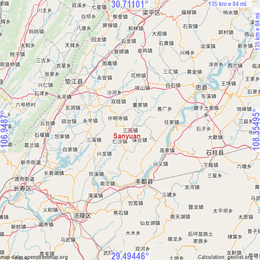
Sanyuan GPS coordinates[2]
30° 6' 16.596" North, 107° 39' 6.552" East
| Map corner | latitude | longitude |
|---|---|---|
| Upper-left | 30.71101°, | 106.9487° |
| Center: | 30.10461°, | 107.65182° |
| Lower-right: | 29.49446°, | 108.35495° |
| Map W x H: | 135.3×135.3 km | = 84.1×84.1mi |
| max Lat: | 53.31946° ⇑52.9% North |
| Sanyuan: | 30.10461° |
| min Lat: | ⇓47.1% South 18.22056° |
| min Long | Sanyuan | max Long |
| 75.07348° | 107.65182° | 134.28917° |
| W 18.3%⇐ | ⇒81.7% E |
Elevation
Elevation of Sanyuan is 211 m = 692 ft, and this is 273.8 m = 898 ft below average elevation for this country.
| Max E: |
5622 m = 18445 ft | 44.5% |
| Avg. | 484.8 m = 1591 ft | |
| Sanyuan | 211 m = 692 ft | |
Min E: |
-3 m = -10 ft | 55.5% |
See also: China elevation on elevation.city.
Geographical zone
Sanyuan is located in North temperate zone (between Tropic of Cancer and the Arctic Circle). Distance of this Northern Tropic circle is 741.4 km =460.7 mi to South.| Distance of | km | miles | from Sanyuan |
|---|---|---|---|
| North Pole | 6659.7 | 4138.1 | to North |
| Arctic Circle | 4053.9 | 2519 | to North |
| Tropic Cancer | 741.4 | 460.7 | to South |
| Equator | 3347.3 | 2079.9 | to South |


Nearby cities:
15 places around Sanyuan: (largest is in red/bold)
• Baohe
6.8 km =4.2 mi,  135°
135°
• Chongxing
18.3 km =11.4 mi,  228°
228°
• Dashi
15.3 km =9.5 mi,  313°
313°
• Dongjia
14.2 km =8.8 mi,  21°
21°
• Gangjia
19.2 km =11.9 mi, 312°
• Peixing
13.1 km =8.1 mi,  280°
280°
• Qinglong
14.5 km =9 mi,  61°
61°
• Rensha
8 km =5 mi,  224°
224°
• Sanxi
19.6 km =12.2 mi,  256°
256°
• Shetan
13.3 km =8.3 mi,  195°
195°
• Shizhi
14.9 km =9.3 mi,  112°
112°
• Shuanggui
16.5 km =10.3 mi,  338°
338°
• Shuanglongchang
7.3 km =4.5 mi,  65°
65°
• Shuren
15.6 km =9.7 mi,  147°
147°
• Xumingsi
9.3 km =5.8 mi, 313°
Sources, notices
• [Note1] Compared only with cities in China existing in our database
• [Src1] Map data: © OpenStreetMap contributors (CC-BY-SA)
• [Src2] Other city data from geonames.org with taken over terms of usage.
• [Src3] Geographical zone / Annual Mean Temperature by Robert A. Rohde @ Wikipedia
