Guanzhuang geodata
Guanzhuang (Chongqing) is a seat of a fourth-order administrative division; located in China in Asia/Shanghai (GMT+8) time zone. In our database, there are 1268 cities with bigger population. Compared to other cities in China, 69.7% of cities are located further ↑North; 76.2% of cities are located further →East and 68% of cities have lower elevation than Guanzhuang. Note1


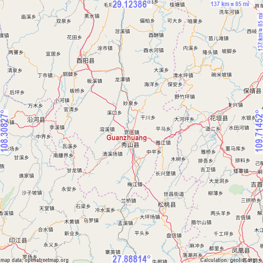
Guanzhuang GPS coordinates[2]
28° 30' 28.116" North, 109° 0' 41.004" East
| Map corner | latitude | longitude |
|---|---|---|
| Upper-left | 29.12386°, | 108.30827° |
| Center: | 28.50781°, | 109.01139° |
| Lower-right: | 27.88814°, | 109.71452° |
| Map W x H: | 137.4×137.4 km | = 85.4×85.4mi |
| max Lat: | 53.31946° ⇑69.7% North |
| Guanzhuang: | 28.50781° |
| min Lat: | ⇓30.3% South 18.22056° |
| min Long | Guanzhuang | max Long |
| 75.07348° | 109.01139° | 134.28917° |
| W 23.8%⇐ | ⇒76.2% E |
Elevation
Elevation of Guanzhuang is 376 m = 1234 ft, and this is 108.8 m = 357 ft below average elevation for this country.
| Max E: |
5622 m = 18445 ft | 32% |
| Avg. | 484.8 m = 1591 ft | |
| Guanzhuang | 376 m = 1234 ft | |
Min E: |
-3 m = -10 ft | 68% |
See also: China elevation on elevation.city.
Geographical zone
Guanzhuang is located in North temperate zone (between Tropic of Cancer and the Arctic Circle). Distance of this Northern Tropic circle is 563.9 km =350.4 mi to South.| Distance of | km | miles | from Guanzhuang |
|---|---|---|---|
| North Pole | 6837.3 | 4248.5 | to North |
| Arctic Circle | 4231.4 | 2629.3 | to North |
| Tropic Cancer | 563.9 | 350.4 | to South |
| Equator | 3169.8 | 1969.6 | to South |


Nearby cities:
15 places around Guanzhuang: (largest is in red/bold)
• Ganchuan
11.4 km =7.1 mi,  47°
47°
• Gaotian
16.8 km =10.4 mi,  263°
263°
• Guanzhou
10.3 km =6.4 mi,  176°
176°
• Jiangfeng
16.3 km =10.1 mi,  330°
330°
• Longchi
11.9 km =7.4 mi,  18°
18°
• Miaoquan
14.8 km =9.2 mi,  357°
357°
• Pingkai
9.2 km =5.7 mi,  189°
189°
• Pingma
16.6 km =10.3 mi,  83°
83°
• Qingxichang
15.6 km =9.7 mi,  222°
222°
• Rongxi
12.9 km =8 mi,  278°
278°
• Shiye
14.7 km =9.1 mi,  162°
162°
• Xikou
13.7 km =8.5 mi,  318°
318°
• Yongdong
15.8 km =9.8 mi,  43°
43°
• Zhonghe
6.7 km =4.2 mi,  198°
198°
• Zhongping
15.4 km =9.6 mi,  131°
131°
Sources, notices
• [Note1] Compared only with cities in China existing in our database
• [Src1] Map data: © OpenStreetMap contributors (CC-BY-SA)
• [Src2] Other city data from geonames.org with taken over terms of usage.
• [Src3] Geographical zone / Annual Mean Temperature by Robert A. Rohde @ Wikipedia
