Nanmu geodata
Nanmu (Chongqing) is a seat of a fourth-order administrative division; located in China in Asia/Shanghai (GMT+8) time zone. In our database, there are 1268 cities with bigger population. Compared to other cities in China, 68.8% of cities are located further ↑North; 77.4% of cities are located further →East and 78.1% of cities have lower elevation than Nanmu. Note1


Nanmu GPS coordinates[2]
28° 36' 12.528" North, 108° 45' 50.148" East
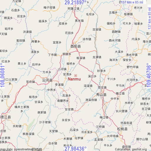
| Map corner | latitude | longitude |
|---|---|---|
| Upper-left | 29.21897°, | 108.06081° |
| Center: | 28.60348°, | 108.76393° |
| Lower-right: | 27.98436°, | 109.46706° |
| Map W x H: | 137.3×137.3 km | = 85.3×85.3mi |
| max Lat: | 53.31946° ⇑68.8% North |
| Nanmu: | 28.60348° |
| min Lat: | ⇓31.2% South 18.22056° |
| min Long | Nanmu | max Long |
| 75.07348° | 108.76393° | 134.28917° |
| W 22.6%⇐ | ⇒77.4% E |
Elevation
Elevation of Nanmu is 618 m = 2028 ft, and this is 133.2 m = 437 ft above average elevation for this country.
| Max E: |
5622 m = 18445 ft | 21.9% |
| Nanmu | 618 m 2028 ft | |
| Avg. | 484.8 m = 1591 ft | |
Min E: |
-3 m = -10 ft | 78.1% |
See also: China elevation on elevation.city.
Geographical zone
Nanmu is located in North temperate zone (between Tropic of Cancer and the Arctic Circle). Distance of this Northern Tropic circle is 574.5 km =357 mi to South.| Distance of | km | miles | from Nanmu |
|---|---|---|---|
| North Pole | 6826.7 | 4241.9 | to North |
| Arctic Circle | 4220.8 | 2622.7 | to North |
| Tropic Cancer | 574.5 | 357 | to South |
| Equator | 3180.4 | 1976.2 | to South |


Nearby cities:
15 places around Nanmu: (largest is in red/bold)
• Banqiao
11.9 km =7.4 mi,  338°
338°
• Banxi
15.4 km =9.6 mi,  19°
19°
• Gaotian
14.7 km =9.1 mi,  149°
149°
• Guanqing
7.7 km =4.8 mi,  283°
283°
• Heita
25.3 km =15.7 mi, 277°
• Jiangfeng
16.5 km =10.3 mi,  77°
77°
• Lixi
17 km =10.6 mi,  241°
241°
• Miaoquan
23.8 km =14.8 mi, 80°
• Rongxi
14.3 km =8.9 mi,  127°
127°
• Shazi
22.7 km =14.1 mi,  254°
254°
• Tang’ao
23.9 km =14.9 mi,  168°
168°
• Tonggu
21.3 km =13.2 mi, 338°
• Waxi
19.6 km =12.2 mi,  204°
204°
• Xiaohe
13.9 km =8.6 mi,  296°
296°
• Xikou
15.1 km =9.4 mi,  91°
91°
Sources, notices
• [Note1] Compared only with cities in China existing in our database
• [Src1] Map data: © OpenStreetMap contributors (CC-BY-SA)
• [Src2] Other city data from geonames.org with taken over terms of usage.
• [Src3] Geographical zone / Annual Mean Temperature by Robert A. Rohde @ Wikipedia
