Waxi geodata
Waxi (Guizhou) is a seat of a fourth-order administrative division; located in China in Asia/Shanghai (GMT+8) time zone. In our database, there are 1268 cities with bigger population. Compared to other cities in China, 70.2% of cities are located further ↑North; 77.8% of cities are located further →East and 76.3% of cities have lower elevation than Waxi. Note1


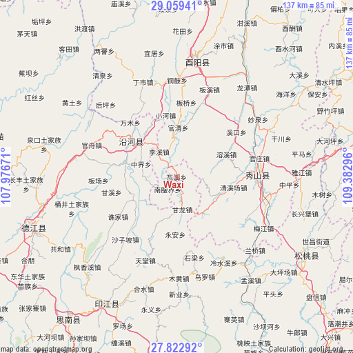
Waxi GPS coordinates[2]
28° 26' 34.692" North, 108° 40' 47.388" East
| Map corner | latitude | longitude |
|---|---|---|
| Upper-left | 29.05941°, | 107.97671° |
| Center: | 28.44297°, | 108.67983° |
| Lower-right: | 27.82292°, | 109.38296° |
| Map W x H: | 137.5×137.5 km | = 85.4×85.4mi |
| max Lat: | 53.31946° ⇑70.2% North |
| Waxi: | 28.44297° |
| min Lat: | ⇓29.8% South 18.22056° |
| min Long | Waxi | max Long |
| 75.07348° | 108.67983° | 134.28917° |
| W 22.2%⇐ | ⇒77.8% E |
Elevation
Elevation of Waxi is 554 m = 1818 ft, and this is 69.2 m = 227 ft above average elevation for this country.
| Max E: |
5622 m = 18445 ft | 23.7% |
| Waxi | 554 m 1818 ft | |
| Avg. | 484.8 m = 1591 ft | |
Min E: |
-3 m = -10 ft | 76.3% |
See also: China elevation on elevation.city.
Geographical zone
Waxi is located in North temperate zone (between Tropic of Cancer and the Arctic Circle). Distance of this Northern Tropic circle is 556.6 km =345.9 mi to South.| Distance of | km | miles | from Waxi |
|---|---|---|---|
| North Pole | 6844.5 | 4253 | to North |
| Arctic Circle | 4238.6 | 2633.7 | to North |
| Tropic Cancer | 556.6 | 345.9 | to South |
| Equator | 3162.6 | 1965.1 | to South |


Nearby cities:
15 places around Waxi: (largest is in red/bold)
• Aikou
17.4 km =10.8 mi,  136°
136°
• Ganlong
12.8 km =8 mi,  169°
169°
• Gaotian
16.6 km =10.3 mi,  71°
71°
• Guanqing
19.6 km =12.2 mi,  1°
1°
• Lixi
11.9 km =7.4 mi,  325°
325°
• Nanmu
19.6 km =12.2 mi,  24°
24°
• Nanyaojie
5.9 km =3.7 mi,  215°
215°
• Qingxichang
22.4 km =13.9 mi,  101°
101°
• Qitan
22.3 km =13.9 mi,  280°
280°
• Rongxi
21.6 km =13.4 mi, 65°
• Shazi
18.1 km =11.2 mi,  310°
310°
• Tang’ao
14.2 km =8.8 mi,  112°
112°
• Xiaojing
10.3 km =6.4 mi,  262°
262°
• Yong’an
22.4 km =13.9 mi,  181°
181°
• Zhongjie
13.4 km =8.3 mi, 279°
Sources, notices
• [Note1] Compared only with cities in China existing in our database
• [Src1] Map data: © OpenStreetMap contributors (CC-BY-SA)
• [Src2] Other city data from geonames.org with taken over terms of usage.
• [Src3] Geographical zone / Annual Mean Temperature by Robert A. Rohde @ Wikipedia
