Shaba geodata
Shaba (Chongqing) is a seat of a fourth-order administrative division; located in China in Asia/Shanghai (GMT+8) time zone. In our database, there are 1268 cities with bigger population. Compared to other cities in China, 59.9% of cities are located further ↑North; 78.3% of cities are located further →East and 75% of cities have lower elevation than Shaba. Note1


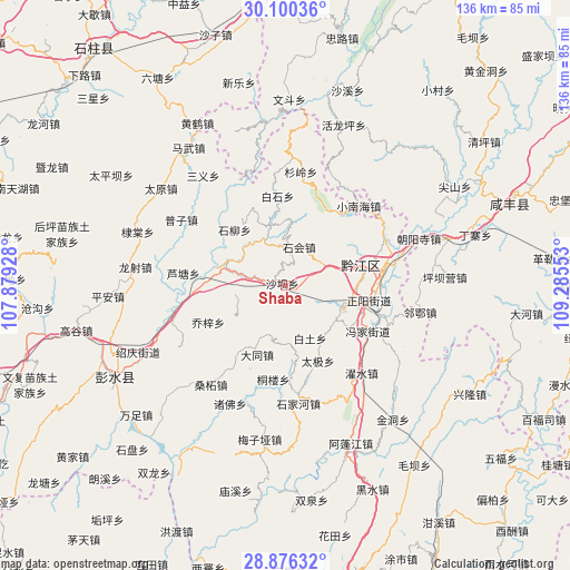
Shaba GPS coordinates[2]
29° 29' 24.684" North, 108° 34' 56.64" East
| Map corner | latitude | longitude |
|---|---|---|
| Upper-left | 30.10036°, | 107.87928° |
| Center: | 29.49019°, | 108.5824° |
| Lower-right: | 28.87632°, | 109.28553° |
| Map W x H: | 136.1×136.1 km | = 84.6×84.6mi |
| max Lat: | 53.31946° ⇑59.9% North |
| Shaba: | 29.49019° |
| min Lat: | ⇓40.1% South 18.22056° |
| min Long | Shaba | max Long |
| 75.07348° | 108.5824° | 134.28917° |
| W 21.7%⇐ | ⇒78.3% E |
Elevation
Elevation of Shaba is 522 m = 1713 ft, and this is 37.2 m = 122 ft above average elevation for this country.
| Max E: |
5622 m = 18445 ft | 25% |
| Shaba | 522 m 1713 ft | |
| Avg. | 484.8 m = 1591 ft | |
Min E: |
-3 m = -10 ft | 75% |
See also: China elevation on elevation.city.
Geographical zone
Shaba is located in North temperate zone (between Tropic of Cancer and the Arctic Circle). Distance of this Northern Tropic circle is 673.1 km =418.2 mi to South.| Distance of | km | miles | from Shaba |
|---|---|---|---|
| North Pole | 6728.1 | 4180.6 | to North |
| Arctic Circle | 4122.2 | 2561.4 | to North |
| Tropic Cancer | 673.1 | 418.2 | to South |
| Equator | 3279 | 2037.5 | to South |


Nearby cities:
15 places around Shaba: (largest is in red/bold)
• Baitu
13.6 km =8.5 mi,  155°
155°
• Chengdong
20.2 km =12.6 mi,  78°
78°
• Chengnan
19.6 km =12.2 mi, 79°
• Daji
19.5 km =12.1 mi, 156°
• Heixi
15.1 km =9.4 mi,  344°
344°
• Jinxi
14.9 km =9.3 mi,  137°
137°
• Lianhe
18.9 km =11.7 mi,  307°
307°
• Longxi
6.9 km =4.3 mi,  250°
250°
• Qianjiang
19.2 km =11.9 mi, 75°
• Shihui
9.5 km =5.9 mi,  16°
16°
• Shuitian
17.9 km =11.1 mi,  123°
123°
• Xiaochang
17.7 km =11 mi,  202°
202°
• Xinhua
18.6 km =11.6 mi,  173°
173°
• Yushan
15.9 km =9.9 mi,  287°
287°
• Zhengyang
20.1 km =12.5 mi,  100°
100°
Sources, notices
• [Note1] Compared only with cities in China existing in our database
• [Src1] Map data: © OpenStreetMap contributors (CC-BY-SA)
• [Src2] Other city data from geonames.org with taken over terms of usage.
• [Src3] Geographical zone / Annual Mean Temperature by Robert A. Rohde @ Wikipedia
