Longxi geodata
Longxi (Chongqing) is a seat of a fourth-order administrative division; located in China in Asia/Shanghai (GMT+8) time zone. In our database, there are 1268 cities with bigger population. Compared to other cities in China, 60.1% of cities are located further ↑North; 78.5% of cities are located further →East and 78.4% of cities have lower elevation than Longxi. Note1


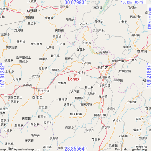
Longxi GPS coordinates[2]
29° 28' 10.668" North, 108° 30' 55.944" East
| Map corner | latitude | longitude |
|---|---|---|
| Upper-left | 30.07993°, | 107.81242° |
| Center: | 29.46963°, | 108.51554° |
| Lower-right: | 28.85564°, | 109.21867° |
| Map W x H: | 136.1×136.1 km | = 84.6×84.6mi |
| max Lat: | 53.31946° ⇑60.1% North |
| Longxi: | 29.46963° |
| min Lat: | ⇓39.9% South 18.22056° |
| min Long | Longxi | max Long |
| 75.07348° | 108.51554° | 134.28917° |
| W 21.5%⇐ | ⇒78.5% E |
Elevation
Elevation of Longxi is 629 m = 2064 ft, and this is 144.2 m = 473 ft above average elevation for this country.
| Max E: |
5622 m = 18445 ft | 21.6% |
| Longxi | 629 m 2064 ft | |
| Avg. | 484.8 m = 1591 ft | |
Min E: |
-3 m = -10 ft | 78.4% |
See also: China elevation on elevation.city.
Geographical zone
Longxi is located in North temperate zone (between Tropic of Cancer and the Arctic Circle). Distance of this Northern Tropic circle is 670.8 km =416.8 mi to South.| Distance of | km | miles | from Longxi |
|---|---|---|---|
| North Pole | 6730.3 | 4182 | to North |
| Arctic Circle | 4124.5 | 2562.8 | to North |
| Tropic Cancer | 670.8 | 416.8 | to South |
| Equator | 3276.7 | 2036 | to South |


Nearby cities:
15 places around Longxi: (largest is in red/bold)
• Baitu
15.8 km =9.8 mi,  129°
129°
• Baojia
19.9 km =12.4 mi,  260°
260°
• Daji
21.1 km =13.1 mi,  137°
137°
• Heixi
17 km =10.6 mi,  8°
8°
• Jinxi
18.7 km =11.6 mi,  117°
117°
• Lianhe
16.2 km =10.1 mi,  327°
327°
• Lutang
18.8 km =11.7 mi,  286°
286°
• Qiaozi
13.6 km =8.5 mi,  242°
242°
• Shaba
6.9 km =4.3 mi,  70°
70°
• Shihui
14.6 km =9.1 mi,  38°
38°
• Shuitian
22.7 km =14.1 mi,  109°
109°
• Tonglou
20.3 km =12.6 mi,  169°
169°
• Xiaochang
14.1 km =8.8 mi,  181°
181°
• Xinhua
18.4 km =11.4 mi,  152°
152°
• Yushan
11.2 km =7 mi,  308°
308°
Sources, notices
• [Note1] Compared only with cities in China existing in our database
• [Src1] Map data: © OpenStreetMap contributors (CC-BY-SA)
• [Src2] Other city data from geonames.org with taken over terms of usage.
• [Src3] Geographical zone / Annual Mean Temperature by Robert A. Rohde @ Wikipedia
