Tangjiakou geodata
Tangjiakou (Tianjin) is a seat of a fourth-order administrative division; located in China in Asia/Shanghai (GMT+8) time zone. In our database, there are 1268 cities with bigger population. Compared to other cities in China, 83.3% of cities are located further ↓South; 67.4% of cities are located further ←West and 94.3% of cities have higher elevation than Tangjiakou. Note1


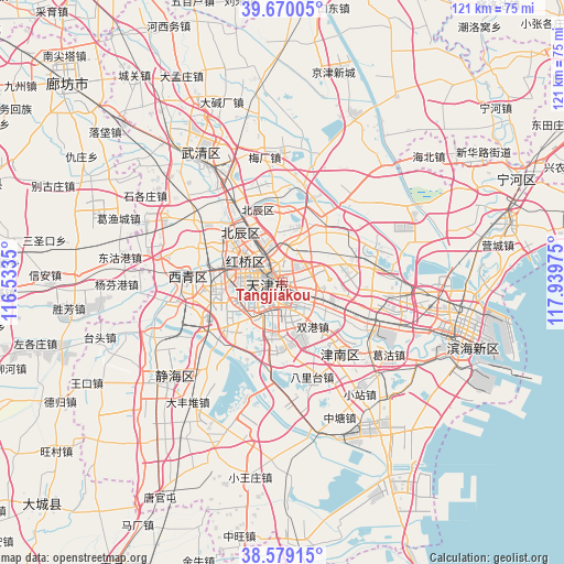
Tangjiakou GPS coordinates[2]
39° 7' 36.156" North, 117° 14' 11.832" East
| Map corner | latitude | longitude |
|---|---|---|
| Upper-left | 39.67005°, | 116.5335° |
| Center: | 39.12671°, | 117.23662° |
| Lower-right: | 38.57915°, | 117.93975° |
| Map W x H: | 121.3×121.3 km | = 75.4×75.4mi |
| max Lat: | 53.31946° ⇑16.7% North |
| Tangjiakou: | 39.12671° |
| min Lat: | ⇓83.3% South 18.22056° |
| min Long | Tangjiakou | max Long |
| 75.07348° | 117.23662° | 134.28917° |
| W 67.4%⇐ | ⇒32.6% E |
Elevation
Elevation of Tangjiakou is 7 m = 23 ft, and this is 477.8 m = 1568 ft below average elevation for this country.
| Max E: |
5622 m = 18445 ft | 94.3% |
| Avg. | 484.8 m = 1591 ft | |
| Tangjiakou | 7 m = 23 ft | |
Min E: |
-3 m = -10 ft | 5.7% |
See also: China elevation on elevation.city.
Geographical zone
Tangjiakou is located in North temperate zone (between Tropic of Cancer and the Arctic Circle). Distance of this Northern Tropic circle is 1744.6 km =1084 mi to South.| Distance of | km | miles | from Tangjiakou |
|---|---|---|---|
| North Pole | 5656.6 | 3514.8 | to North |
| Arctic Circle | 3050.7 | 1895.6 | to North |
| Tropic Cancer | 1744.6 | 1084 | to South |
| Equator | 4350.5 | 2703.3 | to South |


Nearby cities:
15 places around Tangjiakou: (largest is in red/bold)
• Changzhoudao
2.3 km =1.4 mi,  352°
352°
• Chenglin
3.5 km =2.2 mi,  112°
112°
• Chunhua
3.3 km =2.1 mi,  296°
296°
• Dawangzhuang
1.8 km =1.1 mi,  271°
271°
• Dayingmen
3.2 km =2 mi,  227°
227°
• Dazhigu
2 km =1.2 mi,  175°
175°
• Dongxin
3.4 km =2.1 mi,  60°
60°
• Jiangdulu
3.3 km =2.1 mi,  4°
4°
• Quanyechang
3.8 km =2.4 mi,  260°
260°
• Shangkenglu
1.6 km =1 mi,  89°
89°
• Taoyuan
3.6 km =2.2 mi,  198°
198°
• Wangchuanchang
3.5 km =2.2 mi,  327°
327°
• Xiangyanglou
1 km =0.6 mi,  22°
22°
• Xiaobailou
2.9 km =1.8 mi,  249°
249°
• Zhongshanmen
3.8 km =2.4 mi,  140°
140°
Sources, notices
• [Note1] Compared only with cities in China existing in our database
• [Src1] Map data: © OpenStreetMap contributors (CC-BY-SA)
• [Src2] Other city data from geonames.org with taken over terms of usage.
• [Src3] Geographical zone / Annual Mean Temperature by Robert A. Rohde @ Wikipedia
