Xiaobailou geodata
Xiaobailou (Tianjin) is a seat of a third-order administrative division; located in China in Asia/Shanghai (GMT+8) time zone. In our database, there are 1268 cities with bigger population. Compared to other cities in China, 83.3% of cities are located further ↓South; 67.2% of cities are located further ←West and 91.2% of cities have higher elevation than Xiaobailou. Note1


Xiaobailou GPS coordinates[2]
39° 7' 3.576" North, 117° 12' 20.34" East
| Map corner | latitude | longitude |
|---|---|---|
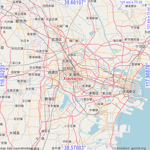
| Upper-left | 39.66107°, | 116.50253° |
| Center: | 39.11766°, | 117.20565° |
| Lower-right: | 38.57003°, | 117.90878° |
| Map W x H: | 121.3×121.3 km | = 75.4×75.4mi |
| max Lat: | 53.31946° ⇑16.7% North |
| Xiaobailou: | 39.11766° |
| min Lat: | ⇓83.3% South 18.22056° |
| min Long | Xiaobailou | max Long |
| 75.07348° | 117.20565° | 134.28917° |
| W 67.2%⇐ | ⇒32.8% E |
Elevation
Elevation of Xiaobailou is 9 m = 30 ft, and this is 475.8 m = 1561 ft below average elevation for this country.
| Max E: |
5622 m = 18445 ft | 91.2% |
| Avg. | 484.8 m = 1591 ft | |
| Xiaobailou | 9 m = 30 ft | |
Min E: |
-3 m = -10 ft | 8.8% |
See also: China elevation on elevation.city.
Geographical zone
Xiaobailou is located in North temperate zone (between Tropic of Cancer and the Arctic Circle). Distance of this Northern Tropic circle is 1743.6 km =1083.4 mi to South.| Distance of | km | miles | from Xiaobailou |
|---|---|---|---|
| North Pole | 5657.6 | 3515.5 | to North |
| Arctic Circle | 3051.7 | 1896.2 | to North |
| Tropic Cancer | 1743.6 | 1083.4 | to South |
| Equator | 4349.5 | 2702.7 | to South |


Nearby cities:
15 places around Xiaobailou: (largest is in red/bold)
• Chunhua
2.5 km =1.6 mi,  353°
353°
• Dawangzhuang
1.4 km =0.9 mi,  41°
41°
• Dayingmen
1.2 km =0.7 mi,  163°
163°
• Dazhigu
3 km =1.9 mi,  109°
109°
• Guangfudao
3.2 km =2 mi, 352°
• Machang
2.4 km =1.5 mi,  208°
208°
• Nanshi
2.3 km =1.4 mi,  295°
295°
• Nanyingmen
2.3 km =1.4 mi,  268°
268°
• Quanyechang
1.2 km =0.7 mi,  290°
290°
• Tangjiakou
2.9 km =1.8 mi,  69°
69°
• Taoyuan
2.9 km =1.8 mi,  148°
148°
• Tiyuguan
1.4 km =0.9 mi,  229°
229°
• Xingnan
3.1 km =1.9 mi, 285°
• Xinxing
2.6 km =1.6 mi,  235°
235°
• Yuexiulu
3.3 km =2.1 mi, 152°
Sources, notices
• [Note1] Compared only with cities in China existing in our database
• [Src1] Map data: © OpenStreetMap contributors (CC-BY-SA)
• [Src2] Other city data from geonames.org with taken over terms of usage.
• [Src3] Geographical zone / Annual Mean Temperature by Robert A. Rohde @ Wikipedia
