Xiangyanglou geodata
Xiangyanglou (Tianjin) is a seat of a fourth-order administrative division; located in China in Asia/Shanghai (GMT+8) time zone. In our database, there are 1268 cities with bigger population. Compared to other cities in China, 83.4% of cities are located further ↓South; 67.4% of cities are located further ←West and 97.2% of cities have higher elevation than Xiangyanglou. Note1


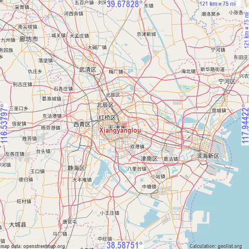
Xiangyanglou GPS coordinates[2]
39° 8' 6.036" North, 117° 14' 27.924" East
| Map corner | latitude | longitude |
|---|---|---|
| Upper-left | 39.67828°, | 116.53797° |
| Center: | 39.13501°, | 117.24109° |
| Lower-right: | 38.58751°, | 117.94422° |
| Map W x H: | 121.3×121.3 km | = 75.4×75.4mi |
| max Lat: | 53.31946° ⇑16.6% North |
| Xiangyanglou: | 39.13501° |
| min Lat: | ⇓83.4% South 18.22056° |
| min Long | Xiangyanglou | max Long |
| 75.07348° | 117.24109° | 134.28917° |
| W 67.4%⇐ | ⇒32.6% E |
Elevation
Elevation of Xiangyanglou is 5 m = 16 ft, and this is 479.8 m = 1574 ft below average elevation for this country.
| Max E: |
5622 m = 18445 ft | 97.2% |
| Avg. | 484.8 m = 1591 ft | |
| Xiangyanglou | 5 m = 16 ft | |
Min E: |
-3 m = -10 ft | 2.8% |
See also: China elevation on elevation.city.
Geographical zone
Xiangyanglou is located in North temperate zone (between Tropic of Cancer and the Arctic Circle). Distance of this Northern Tropic circle is 1745.5 km =1084.6 mi to South.| Distance of | km | miles | from Xiangyanglou |
|---|---|---|---|
| North Pole | 5655.7 | 3514.3 | to North |
| Arctic Circle | 3049.8 | 1895.1 | to North |
| Tropic Cancer | 1745.5 | 1084.6 | to South |
| Equator | 4351.4 | 2703.8 | to South |


Nearby cities:
15 places around Xiangyanglou: (largest is in red/bold)
• Changzhoudao
1.5 km =0.9 mi,  333°
333°
• Chenglin
3.6 km =2.2 mi,  128°
128°
• Chunhua
3.4 km =2.1 mi,  279°
279°
• Dawangzhuang
2.3 km =1.4 mi,  247°
247°
• Dayingmen
4.1 km =2.5 mi,  221°
221°
• Dazhigu
2.9 km =1.8 mi,  184°
184°
• Dongxin
2.7 km =1.7 mi,  74°
74°
• Guangfudao
3.7 km =2.3 mi,  289°
289°
• Jiangdulu
2.3 km =1.4 mi,  356°
356°
• Shangkenglu
1.5 km =0.9 mi, 127°
• Tangjiakou
1 km =0.6 mi,  202°
202°
• Wangchuanchang
3.1 km =1.9 mi,  312°
312°
• Xiaobailou
3.6 km =2.2 mi,  237°
237°
• Yueyahe
3.1 km =1.9 mi,  0°
0°
• Zhaoguli
3.5 km =2.2 mi, 1°
Sources, notices
• [Note1] Compared only with cities in China existing in our database
• [Src1] Map data: © OpenStreetMap contributors (CC-BY-SA)
• [Src2] Other city data from geonames.org with taken over terms of usage.
• [Src3] Geographical zone / Annual Mean Temperature by Robert A. Rohde @ Wikipedia
