Erhaoqiao geodata
Erhaoqiao (Tianjin) is a seat of a fourth-order administrative division; located in China in Asia/Shanghai (GMT+8) time zone. In our database, there are 1268 cities with bigger population. Compared to other cities in China, 83.1% of cities are located further ↓South; 67.7% of cities are located further ←West and 94.3% of cities have higher elevation than Erhaoqiao. Note1


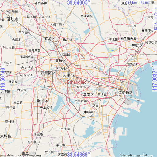
Erhaoqiao GPS coordinates[2]
39° 5' 47.328" North, 117° 17' 26.088" East
| Map corner | latitude | longitude |
|---|---|---|
| Upper-left | 39.64005°, | 116.58746° |
| Center: | 39.09648°, | 117.29058° |
| Lower-right: | 38.54869°, | 117.99371° |
| Map W x H: | 121.3×121.3 km | = 75.4×75.4mi |
| max Lat: | 53.31946° ⇑16.9% North |
| Erhaoqiao: | 39.09648° |
| min Lat: | ⇓83.1% South 18.22056° |
| min Long | Erhaoqiao | max Long |
| 75.07348° | 117.29058° | 134.28917° |
| W 67.7%⇐ | ⇒32.3% E |
Elevation
Elevation of Erhaoqiao is 7 m = 23 ft, and this is 477.8 m = 1568 ft below average elevation for this country.
| Max E: |
5622 m = 18445 ft | 94.3% |
| Avg. | 484.8 m = 1591 ft | |
| Erhaoqiao | 7 m = 23 ft | |
Min E: |
-3 m = -10 ft | 5.7% |
See also: China elevation on elevation.city.
Geographical zone
Erhaoqiao is located in North temperate zone (between Tropic of Cancer and the Arctic Circle). Distance of this Northern Tropic circle is 1741.2 km =1081.9 mi to South.| Distance of | km | miles | from Erhaoqiao |
|---|---|---|---|
| North Pole | 5659.9 | 3516.9 | to North |
| Arctic Circle | 3054.1 | 1897.7 | to North |
| Tropic Cancer | 1741.2 | 1081.9 | to South |
| Equator | 4347.1 | 2701.2 | to South |


Nearby cities:
15 places around Erhaoqiao: (largest is in red/bold)
• Chenglin
2.5 km =1.6 mi,  324°
324°
• Chentangzhuang
4.2 km =2.6 mi,  219°
219°
• Cuijiamatou
2.6 km =1.6 mi,  160°
160°
• Dazhigu
4.7 km =2.9 mi,  286°
286°
• Dongxin
5.3 km =3.3 mi,  341°
341°
• Fengniancun
3.6 km =2.2 mi,  115°
115°
• Fuminlu
3.5 km =2.2 mi,  254°
254°
• Guajiasi
5.6 km =3.5 mi,  263°
263°
• Jianshan
5.8 km =3.6 mi, 259°
• Liulin
4.2 km =2.6 mi,  211°
211°
• Shangkenglu
4.6 km =2.9 mi, 317°
• Tangjiakou
5.7 km =3.5 mi,  305°
305°
• Xinli
4.1 km =2.5 mi,  108°
108°
• Zhangguizhuang
1.6 km =1 mi, 115°
• Zhongshanmen
2.2 km =1.4 mi,  280°
280°
Sources, notices
• [Note1] Compared only with cities in China existing in our database
• [Src1] Map data: © OpenStreetMap contributors (CC-BY-SA)
• [Src2] Other city data from geonames.org with taken over terms of usage.
• [Src3] Geographical zone / Annual Mean Temperature by Robert A. Rohde @ Wikipedia
