Cuijiamatou geodata
Cuijiamatou (Tianjin) is a populated place; located in China in Asia/Shanghai (GMT+8) time zone. With population of 1,990 people, there are 1034 cities with bigger population in this country. Compared to other cities in China, 83% of cities are located further ↓South; 67.8% of cities are located further ←West and 99.7% of cities have higher elevation than Cuijiamatou. Note1


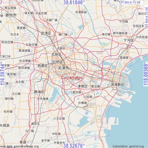
Cuijiamatou GPS coordinates[2]
39° 4' 28.992" North, 117° 18' 2.016" East
| Map corner | latitude | longitude |
|---|---|---|
| Upper-left | 39.61846°, | 116.59744° |
| Center: | 39.07472°, | 117.30056° |
| Lower-right: | 38.52676°, | 118.00369° |
| Map W x H: | 121.4×121.4 km | = 75.4×75.4mi |
| max Lat: | 53.31946° ⇑17% North |
| Cuijiamatou: | 39.07472° |
| min Lat: | ⇓83% South 18.22056° |
| min Long | Cuijiamatou | max Long |
| 75.07348° | 117.30056° | 134.28917° |
| W 67.8%⇐ | ⇒32.2% E |
Elevation
Elevation of Cuijiamatou is 1 m = 3 ft, and this is 483.8 m = 1587 ft below average elevation for this country.
| Max E: |
5622 m = 18445 ft | 99.7% |
| Avg. | 484.8 m = 1591 ft | |
| Cuijiamatou | 1 m = 3 ft | |
Min E: |
-3 m = -10 ft | 0.3% |
See also: China elevation on elevation.city.
Geographical zone
Cuijiamatou is located in North temperate zone (between Tropic of Cancer and the Arctic Circle). Distance of this Northern Tropic circle is 1738.8 km =1080.4 mi to South.| Distance of | km | miles | from Cuijiamatou |
|---|---|---|---|
| North Pole | 5662.4 | 3518.5 | to North |
| Arctic Circle | 3056.5 | 1899.2 | to North |
| Tropic Cancer | 1738.8 | 1080.4 | to South |
| Equator | 4344.7 | 2699.7 | to South |


Nearby cities:
15 places around Cuijiamatou: (largest is in red/bold)
• Chenglin
5 km =3.1 mi,  332°
332°
• Chentangzhuang
3.7 km =2.3 mi,  256°
256°
• Darenzhuang
5.8 km =3.6 mi,  226°
226°
• Dazhigu
6.6 km =4.1 mi,  305°
305°
• Donghai
5.3 km =3.3 mi,  241°
241°
• Erhaoqiao
2.6 km =1.6 mi,  340°
340°
• Fengniancun
2.5 km =1.6 mi,  70°
70°
• Fuminlu
4.5 km =2.8 mi,  289°
289°
• Liulin
3.3 km =2.1 mi,  248°
248°
• Luotuofangzi
6.7 km =4.2 mi,  81°
81°
• Shuanggang
3.5 km =2.2 mi,  166°
166°
• Xinli
3.2 km =2 mi, 69°
• Xinzhuang
6.7 km =4.2 mi,  146°
146°
• Zhangguizhuang
1.8 km =1.1 mi,  18°
18°
• Zhongshanmen
4.2 km =2.6 mi, 312°
Sources, notices
• [Note1] Compared only with cities in China existing in our database
• [Src1] Map data: © OpenStreetMap contributors (CC-BY-SA)
• [Src2] Other city data from geonames.org with taken over terms of usage.
• [Src3] Geographical zone / Annual Mean Temperature by Robert A. Rohde @ Wikipedia
