Daruoyan geodata
Daruoyan (Chongqing) is a seat of a fourth-order administrative division; located in China in Asia/Shanghai (GMT+8) time zone. In our database, there are 1268 cities with bigger population. Compared to other cities in China, 71.6% of cities are located further ↑North; 85.8% of cities are located further ←West and 67.6% of cities have higher elevation than Daruoyan. Note1


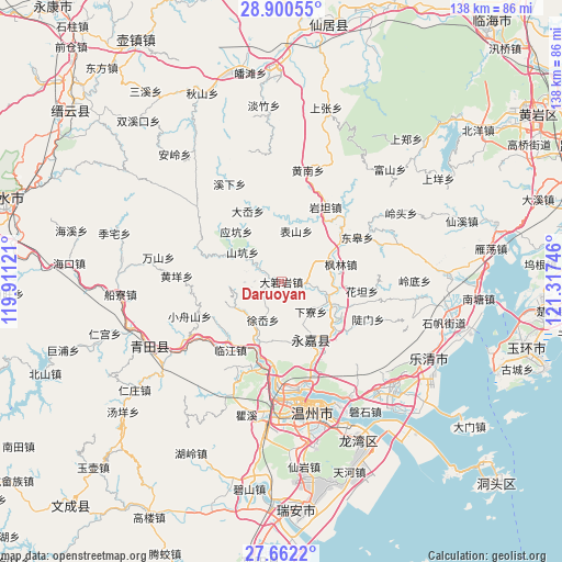
Daruoyan GPS coordinates[2]
28° 16' 59.448" North, 120° 36' 51.588" East
| Map corner | latitude | longitude |
|---|---|---|
| Upper-left | 28.90055°, | 119.91121° |
| Center: | 28.28318°, | 120.61433° |
| Lower-right: | 27.6622°, | 121.31746° |
| Map W x H: | 137.7×137.7 km | = 85.6×85.6mi |
| max Lat: | 53.31946° ⇑71.6% North |
| Daruoyan: | 28.28318° |
| min Lat: | ⇓28.4% South 18.22056° |
| min Long | Daruoyan | max Long |
| 75.07348° | 120.61433° | 134.28917° |
| W 85.8%⇐ | ⇒14.2% E |
Elevation
Elevation of Daruoyan is 62 m = 203 ft, and this is 422.8 m = 1387 ft below average elevation for this country.
| Max E: |
5622 m = 18445 ft | 67.6% |
| Avg. | 484.8 m = 1591 ft | |
| Daruoyan | 62 m = 203 ft | |
Min E: |
-3 m = -10 ft | 32.4% |
See also: China elevation on elevation.city.
Geographical zone
Daruoyan is located in North temperate zone (between Tropic of Cancer and the Arctic Circle). Distance of this Northern Tropic circle is 538.9 km =334.9 mi to South.| Distance of | km | miles | from Daruoyan |
|---|---|---|---|
| North Pole | 6862.3 | 4264 | to North |
| Arctic Circle | 4256.4 | 2644.8 | to North |
| Tropic Cancer | 538.9 | 334.9 | to South |
| Equator | 3144.8 | 1954.1 | to South |


Nearby cities:
15 places around Daruoyan: (largest is in red/bold)
• Biaoshan
13 km =8.1 mi,  16°
16°
• Bilian
6.6 km =4.1 mi,  300°
300°
• Fenglin
15.2 km =9.4 mi,  73°
73°
• Kunyang
6 km =3.7 mi,  234°
234°
• Ming’ao
9 km =5.6 mi,  268°
268°
• Qiaoxia
13.9 km =8.6 mi,  204°
204°
• Qukou
10.7 km =6.6 mi,  100°
100°
• Shangtang
15.9 km =9.9 mi,  153°
153°
• Shankeng
12 km =7.5 mi,  307°
307°
• Xialiao
10.3 km =6.4 mi,  135°
135°
• Xixi
11.8 km =7.3 mi, 229°
• Xunzhai
14.9 km =9.3 mi, 298°
• Xu’ao
10.3 km =6.4 mi,  205°
205°
• Yantou
13 km =8.1 mi,  60°
60°
• Yingkeng
16.5 km =10.3 mi,  318°
318°
Sources, notices
• [Note1] Compared only with cities in China existing in our database
• [Src1] Map data: © OpenStreetMap contributors (CC-BY-SA)
• [Src2] Other city data from geonames.org with taken over terms of usage.
• [Src3] Geographical zone / Annual Mean Temperature by Robert A. Rohde @ Wikipedia
