Longqiao geodata
Longqiao (Chongqing) is a seat of a fourth-order administrative division; located in China in Asia/Shanghai (GMT+8) time zone. In our database, there are 1268 cities with bigger population. Compared to other cities in China, 57.3% of cities are located further ↑North; 82.9% of cities are located further →East and 57.8% of cities have lower elevation than Longqiao. Note1


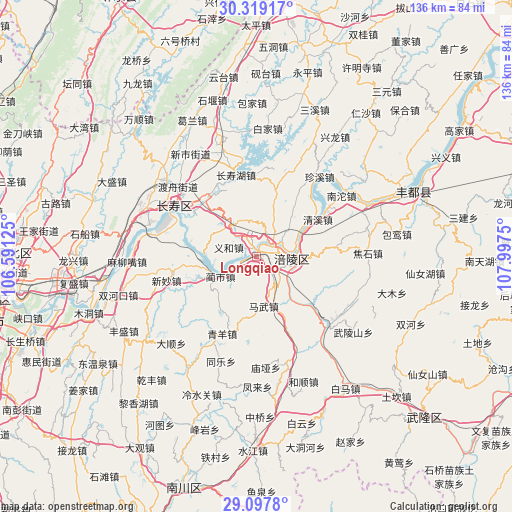
Longqiao GPS coordinates[2]
29° 42' 37.224" North, 107° 17' 39.732" East
| Map corner | latitude | longitude |
|---|---|---|
| Upper-left | 30.31917°, | 106.59125° |
| Center: | 29.71034°, | 107.29437° |
| Lower-right: | 29.0978°, | 107.9975° |
| Map W x H: | 135.8×135.8 km | = 84.4×84.4mi |
| max Lat: | 53.31946° ⇑57.3% North |
| Longqiao: | 29.71034° |
| min Lat: | ⇓42.7% South 18.22056° |
| min Long | Longqiao | max Long |
| 75.07348° | 107.29437° | 134.28917° |
| W 17.1%⇐ | ⇒82.9% E |
Elevation
Elevation of Longqiao is 234 m = 768 ft, and this is 250.8 m = 823 ft below average elevation for this country.
| Max E: |
5622 m = 18445 ft | 42.2% |
| Avg. | 484.8 m = 1591 ft | |
| Longqiao | 234 m = 768 ft | |
Min E: |
-3 m = -10 ft | 57.8% |
See also: China elevation on elevation.city.
Geographical zone
Longqiao is located in North temperate zone (between Tropic of Cancer and the Arctic Circle). Distance of this Northern Tropic circle is 697.6 km =433.5 mi to South.| Distance of | km | miles | from Longqiao |
|---|---|---|---|
| North Pole | 6703.6 | 4165.4 | to North |
| Arctic Circle | 4097.7 | 2546.2 | to North |
| Tropic Cancer | 697.6 | 433.5 | to South |
| Equator | 3303.5 | 2052.7 | to South |


Nearby cities:
15 places around Longqiao: (largest is in red/bold)
• Baisheng
14.9 km =9.3 mi,  39°
39°
• Baozi
16.2 km =10.1 mi,  225°
225°
• Fuling
9.8 km =6.1 mi,  92°
92°
• Huimin
12.1 km =7.5 mi,  209°
209°
• Jiudian
8.6 km =5.3 mi,  149°
149°
• Lidu
5.6 km =3.5 mi,  339°
339°
• Linshi
11 km =6.8 mi,  243°
243°
• Lizhi
9.8 km =6.1 mi, 94°
• Mawu
13.2 km =8.2 mi,  172°
172°
• Shilong
11.7 km =7.3 mi,  0°
0°
• Shituo
15.3 km =9.5 mi,  272°
272°
• Tiantai
16.8 km =10.4 mi,  111°
111°
• Yihe
7.9 km =4.9 mi,  292°
292°
• Zhen’an
13.9 km =8.6 mi, 273°
• Zhihan
9.9 km =6.2 mi,  347°
347°
Sources, notices
• [Note1] Compared only with cities in China existing in our database
• [Src1] Map data: © OpenStreetMap contributors (CC-BY-SA)
• [Src2] Other city data from geonames.org with taken over terms of usage.
• [Src3] Geographical zone / Annual Mean Temperature by Robert A. Rohde @ Wikipedia
