Fuling geodata
Fuling (Chongqing) is a populated place; located in China in Asia/Shanghai (GMT+8) time zone. With population of 166,507 people, there are 265 cities with bigger population in this country. Compared to other cities in China, 57.4% of cities are located further ↑North; 82.5% of cities are located further →East and 60.3% of cities have lower elevation than Fuling. Note1


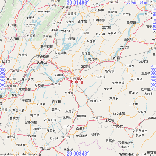
Fuling GPS coordinates[2]
29° 42' 21.6" North, 107° 23' 44.7" East
| Map corner | latitude | longitude |
|---|---|---|
| Upper-left | 30.31486°, | 106.69263° |
| Center: | 29.706°, | 107.39575° |
| Lower-right: | 29.09343°, | 108.09888° |
| Map W x H: | 135.8×135.8 km | = 84.4×84.4mi |
| max Lat: | 53.31946° ⇑57.4% North |
| Fuling: | 29.706° |
| min Lat: | ⇓42.6% South 18.22056° |
| min Long | Fuling | max Long |
| 75.07348° | 107.39575° | 134.28917° |
| W 17.5%⇐ | ⇒82.5% E |
Elevation
Elevation of Fuling is 263 m = 863 ft, and this is 221.8 m = 728 ft below average elevation for this country.
| Max E: |
5622 m = 18445 ft | 39.7% |
| Avg. | 484.8 m = 1591 ft | |
| Fuling | 263 m = 863 ft | |
Min E: |
-3 m = -10 ft | 60.3% |
See also: Fuling elevation on elevation.city.
Geographical zone
Fuling is located in North temperate zone (between Tropic of Cancer and the Arctic Circle). Distance of this Northern Tropic circle is 697.1 km =433.2 mi to South.| Distance of | km | miles | from Fuling |
|---|---|---|---|
| North Pole | 6704.1 | 4165.7 | to North |
| Arctic Circle | 4098.2 | 2546.5 | to North |
| Tropic Cancer | 697.1 | 433.2 | to South |
| Equator | 3303 | 2052.4 | to South |


Nearby cities:
15 places around Fuling: (largest is in red/bold)
• Baisheng
12 km =7.5 mi,  358°
358°
• Baitao
19.4 km =12.1 mi,  152°
152°
• Conglin
18.8 km =11.7 mi,  345°
345°
• Huimin
18.7 km =11.6 mi,  237°
237°
• Jiudian
8.8 km =5.5 mi,  217°
217°
• Lidu
13.1 km =8.1 mi,  295°
295°
• Lizhi
0.3 km =0.2 mi,  189°
189°
• Longqiao
9.8 km =6.1 mi,  272°
272°
• Mawu
14.9 km =9.3 mi,  212°
212°
• Qingxi
11.9 km =7.4 mi,  30°
30°
• Shilong
15.6 km =9.7 mi,  321°
321°
• Tiantai
8.2 km =5.1 mi,  134°
134°
• Yihe
17.4 km =10.8 mi,  281°
281°
• Zhihan
15.7 km =9.8 mi,  310°
310°
• Zili
15.7 km =9.8 mi, 188°
Sources, notices
• [Note1] Compared only with cities in China existing in our database
• [Src1] Map data: © OpenStreetMap contributors (CC-BY-SA)
• [Src2] Other city data from geonames.org with taken over terms of usage.
• [Src3] Geographical zone / Annual Mean Temperature by Robert A. Rohde @ Wikipedia
