Tiantai geodata
Tiantai (Chongqing) is a seat of a fourth-order administrative division; located in China in Asia/Shanghai (GMT+8) time zone. In our database, there are 1268 cities with bigger population. Compared to other cities in China, 58% of cities are located further ↑North; 82.3% of cities are located further →East and 79.9% of cities have lower elevation than Tiantai. Note1


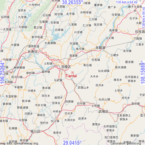
Tiantai GPS coordinates[2]
29° 39' 15.768" North, 107° 27' 20.736" East
| Map corner | latitude | longitude |
|---|---|---|
| Upper-left | 30.26355°, | 106.75264° |
| Center: | 29.65438°, | 107.45576° |
| Lower-right: | 29.0415°, | 108.15889° |
| Map W x H: | 135.9×135.9 km | = 84.4×84.4mi |
| max Lat: | 53.31946° ⇑58% North |
| Tiantai: | 29.65438° |
| min Lat: | ⇓42% South 18.22056° |
| min Long | Tiantai | max Long |
| 75.07348° | 107.45576° | 134.28917° |
| W 17.7%⇐ | ⇒82.3% E |
Elevation
Elevation of Tiantai is 693 m = 2274 ft, and this is 208.2 m = 683 ft above average elevation for this country.
| Max E: |
5622 m = 18445 ft | 20.1% |
| Tiantai | 693 m 2274 ft | |
| Avg. | 484.8 m = 1591 ft | |
Min E: |
-3 m = -10 ft | 79.9% |
See also: China elevation on elevation.city.
Geographical zone
Tiantai is located in North temperate zone (between Tropic of Cancer and the Arctic Circle). Distance of this Northern Tropic circle is 691.3 km =429.6 mi to South.| Distance of | km | miles | from Tiantai |
|---|---|---|---|
| North Pole | 6709.8 | 4169.3 | to North |
| Arctic Circle | 4103.9 | 2550 | to North |
| Tropic Cancer | 691.3 | 429.6 | to South |
| Equator | 3297.3 | 2048.8 | to South |


Nearby cities:
15 places around Tiantai: (largest is in red/bold)
• Baisheng
18.7 km =11.6 mi,  340°
340°
• Baitao
11.9 km =7.4 mi,  165°
165°
• Damu
20.4 km =12.7 mi,  101°
101°
• Fuling
8.2 km =5.1 mi,  314°
314°
• Jiaoshi
15.3 km =9.5 mi,  63°
63°
• Jiudian
11.3 km =7 mi,  263°
263°
• Lizhi
8 km =5 mi, 312°
• Longqiao
16.8 km =10.4 mi,  291°
291°
• Luoyun
19.6 km =12.2 mi,  44°
44°
• Mawu
15.4 km =9.6 mi,  243°
243°
• Qingxi
16 km =9.9 mi,  0°
0°
• Shanwo
11.8 km =7.3 mi,  114°
114°
• Taihe
19.9 km =12.4 mi,  223°
223°
• Wulongshan
17.1 km =10.6 mi,  143°
143°
• Zili
12.8 km =8 mi, 219°
Sources, notices
• [Note1] Compared only with cities in China existing in our database
• [Src1] Map data: © OpenStreetMap contributors (CC-BY-SA)
• [Src2] Other city data from geonames.org with taken over terms of usage.
• [Src3] Geographical zone / Annual Mean Temperature by Robert A. Rohde @ Wikipedia
