Longxing geodata
Longxing (Chongqing) is a seat of a fourth-order administrative division; located in China in Asia/Shanghai (GMT+8) time zone. In our database, there are 1268 cities with bigger population. Compared to other cities in China, 52.1% of cities are located further ↑North; 86.7% of cities are located further →East and 67.6% of cities have lower elevation than Longxing. Note1


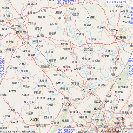
Longxing GPS coordinates[2]
30° 11' 30.876" North, 106° 3' 31.68" East
| Map corner | latitude | longitude |
|---|---|---|
| Upper-left | 30.79777°, | 105.35568° |
| Center: | 30.19191°, | 106.0588° |
| Lower-right: | 29.5823°, | 106.76193° |
| Map W x H: | 135.1×135.1 km | = 83.9×83.9mi |
| max Lat: | 53.31946° ⇑52.1% North |
| Longxing: | 30.19191° |
| min Lat: | ⇓47.9% South 18.22056° |
| min Long | Longxing | max Long |
| 75.07348° | 106.0588° | 134.28917° |
| W 13.3%⇐ | ⇒86.7% E |
Elevation
Elevation of Longxing is 369 m = 1211 ft, and this is 115.8 m = 380 ft below average elevation for this country.
| Max E: |
5622 m = 18445 ft | 32.4% |
| Avg. | 484.8 m = 1591 ft | |
| Longxing | 369 m = 1211 ft | |
Min E: |
-3 m = -10 ft | 67.6% |
See also: China elevation on elevation.city.
Geographical zone
Longxing is located in North temperate zone (between Tropic of Cancer and the Arctic Circle). Distance of this Northern Tropic circle is 751.1 km =466.7 mi to South.| Distance of | km | miles | from Longxing |
|---|---|---|---|
| North Pole | 6650 | 4132.1 | to North |
| Arctic Circle | 4044.1 | 2512.9 | to North |
| Tropic Cancer | 751.1 | 466.7 | to South |
| Equator | 3357 | 2085.9 | to South |


Nearby cities:
15 places around Longxing: (largest is in red/bold)
• Anju
22.5 km =14 mi,  186°
186°
• Biekou
12.8 km =8 mi,  229°
229°
• Dashi
19.1 km =11.9 mi,  124°
124°
• Erlang
20 km =12.4 mi,  341°
341°
• Gaolou
17.8 km =11.1 mi,  205°
205°
• Gulou
11 km =6.8 mi,  99°
99°
• Longfeng
9.2 km =5.7 mi, 337°
• Longxing
15.9 km =9.9 mi,  294°
294°
• Sanmiao
8.3 km =5.2 mi,  52°
52°
• Shanghe
12.5 km =7.8 mi,  253°
253°
• Taihe
10.3 km =6.4 mi, 185°
• Tongxi
22.4 km =13.9 mi,  162°
162°
• Weituo
18.9 km =11.7 mi,  153°
153°
• Yanwo
15.6 km =9.7 mi,  5°
5°
• Zitong
22.1 km =13.7 mi,  266°
266°
Sources, notices
• [Note1] Compared only with cities in China existing in our database
• [Src1] Map data: © OpenStreetMap contributors (CC-BY-SA)
• [Src2] Other city data from geonames.org with taken over terms of usage.
• [Src3] Geographical zone / Annual Mean Temperature by Robert A. Rohde @ Wikipedia
