Baoding geodata
Baoding (Chongqing) is a seat of a fourth-order administrative division; located in China in Asia/Shanghai (GMT+8) time zone. In our database, there are 1268 cities with bigger population. Compared to other cities in China, 56.9% of cities are located further ↑North; 87.6% of cities are located further →East and 68.4% of cities have lower elevation than Baoding. Note1


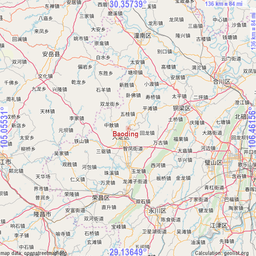
Baoding GPS coordinates[2]
29° 44' 55.68" North, 105° 45' 30.348" East
| Map corner | latitude | longitude |
|---|---|---|
| Upper-left | 30.35739°, | 105.05531° |
| Center: | 29.7488°, | 105.75843° |
| Lower-right: | 29.13649°, | 106.46156° |
| Map W x H: | 135.8×135.8 km | = 84.4×84.4mi |
| max Lat: | 53.31946° ⇑56.9% North |
| Baoding: | 29.7488° |
| min Lat: | ⇓43.1% South 18.22056° |
| min Long | Baoding | max Long |
| 75.07348° | 105.75843° | 134.28917° |
| W 12.4%⇐ | ⇒87.6% E |
Elevation
Elevation of Baoding is 383 m = 1257 ft, and this is 101.8 m = 334 ft below average elevation for this country.
| Max E: |
5622 m = 18445 ft | 31.6% |
| Avg. | 484.8 m = 1591 ft | |
| Baoding | 383 m = 1257 ft | |
Min E: |
-3 m = -10 ft | 68.4% |
See also: China elevation on elevation.city.
Geographical zone
Baoding is located in North temperate zone (between Tropic of Cancer and the Arctic Circle). Distance of this Northern Tropic circle is 701.8 km =436.1 mi to South.| Distance of | km | miles | from Baoding |
|---|---|---|---|
| North Pole | 6699.3 | 4162.8 | to North |
| Arctic Circle | 4093.4 | 2543.5 | to North |
| Tropic Cancer | 701.8 | 436.1 | to South |
| Equator | 3307.8 | 2055.4 | to South |


Nearby cities:
15 places around Baoding: (largest is in red/bold)
• Baoxing
15.5 km =9.6 mi,  204°
204°
• Gaoping
13.6 km =8.5 mi,  319°
319°
• Gaosheng
17.7 km =11 mi,  258°
258°
• Guoliang
15.9 km =9.9 mi,  83°
83°
• Huilong
10.3 km =6.4 mi,  102°
102°
• Jinshan
15.1 km =9.4 mi,  127°
127°
• Longgang
7.2 km =4.5 mi,  217°
217°
• Pingtan
15.8 km =9.8 mi,  46°
46°
• Shima
14.8 km =9.2 mi,  151°
151°
• Shuangshan
10.5 km =6.5 mi,  40°
40°
• Tangxiang
6.2 km =3.9 mi,  212°
212°
• Wugui
7.8 km =4.8 mi,  358°
358°
• Xiaolin
10 km =6.2 mi,  64°
64°
• Zhifeng
10.8 km =6.7 mi,  166°
166°
• Zhong’ao
9.1 km =5.7 mi,  281°
281°
Sources, notices
• [Note1] Compared only with cities in China existing in our database
• [Src1] Map data: © OpenStreetMap contributors (CC-BY-SA)
• [Src2] Other city data from geonames.org with taken over terms of usage.
• [Src3] Geographical zone / Annual Mean Temperature by Robert A. Rohde @ Wikipedia
