Huilong geodata
Huilong (Chongqing) is a seat of a fourth-order administrative division; located in China in Asia/Shanghai (GMT+8) time zone. In our database, there are 1268 cities with bigger population. Compared to other cities in China, 57.1% of cities are located further ↑North; 87.3% of cities are located further →East and 62.8% of cities have lower elevation than Huilong. Note1


Huilong GPS coordinates[2]
29° 43' 42.924" North, 105° 51' 46.404" East
| Map corner | latitude | longitude |
|---|---|---|
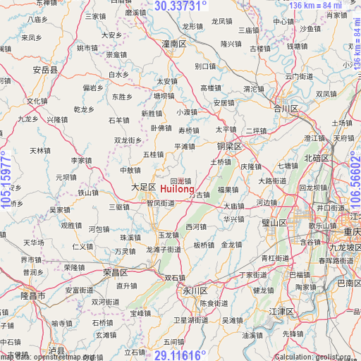
| Upper-left | 30.33731°, | 105.15977° |
| Center: | 29.72859°, | 105.86289° |
| Lower-right: | 29.11616°, | 106.56602° |
| Map W x H: | 135.8×135.8 km | = 84.4×84.4mi |
| max Lat: | 53.31946° ⇑57.1% North |
| Huilong: | 29.72859° |
| min Lat: | ⇓42.9% South 18.22056° |
| min Long | Huilong | max Long |
| 75.07348° | 105.86289° | 134.28917° |
| W 12.7%⇐ | ⇒87.3% E |
Elevation
Elevation of Huilong is 293 m = 961 ft, and this is 191.8 m = 629 ft below average elevation for this country.
| Max E: |
5622 m = 18445 ft | 37.2% |
| Avg. | 484.8 m = 1591 ft | |
| Huilong | 293 m = 961 ft | |
Min E: |
-3 m = -10 ft | 62.8% |
See also: China elevation on elevation.city.
Geographical zone
Huilong is located in North temperate zone (between Tropic of Cancer and the Arctic Circle). Distance of this Northern Tropic circle is 699.6 km =434.7 mi to South.| Distance of | km | miles | from Huilong |
|---|---|---|---|
| North Pole | 6701.6 | 4164.2 | to North |
| Arctic Circle | 4095.7 | 2544.9 | to North |
| Tropic Cancer | 699.6 | 434.7 | to South |
| Equator | 3305.5 | 2053.9 | to South |


Nearby cities:
15 places around Huilong: (largest is in red/bold)
• Baoding
10.3 km =6.4 mi,  282°
282°
• Gulong
13.9 km =8.6 mi,  101°
101°
• Guoliang
7 km =4.3 mi,  54°
54°
• Jinshan
7.2 km =4.5 mi,  165°
165°
• Longgang
14.8 km =9.2 mi,  256°
256°
• Pingtan
13.1 km =8.1 mi,  6°
6°
• Shima
11.3 km =7 mi,  196°
196°
• Shiwan
13 km =8.1 mi, 166°
• Shuangshan
10.8 km =6.7 mi,  342°
342°
• Tangxiang
13.8 km =8.6 mi, 257°
• Wangu
8.7 km =5.4 mi,  126°
126°
• Wugui
14.4 km =8.9 mi,  314°
314°
• Xiaolin
6.7 km =4.2 mi,  350°
350°
• Yongxi
11.3 km =7 mi,  84°
84°
• Zhifeng
11.2 km =7 mi,  222°
222°
Sources, notices
• [Note1] Compared only with cities in China existing in our database
• [Src1] Map data: © OpenStreetMap contributors (CC-BY-SA)
• [Src2] Other city data from geonames.org with taken over terms of usage.
• [Src3] Geographical zone / Annual Mean Temperature by Robert A. Rohde @ Wikipedia
