Yongrong geodata
Yongrong (Chongqing) is a seat of a fourth-order administrative division; located in China in Asia/Shanghai (GMT+8) time zone. In our database, there are 1268 cities with bigger population. Compared to other cities in China, 61.5% of cities are located further ↑North; 88% of cities are located further →East and 72% of cities have lower elevation than Yongrong. Note1


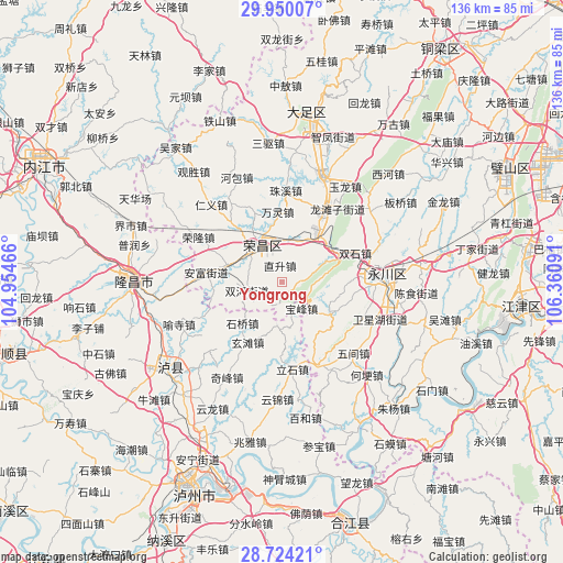
Yongrong GPS coordinates[2]
29° 20' 20.328" North, 105° 39' 28.008" East
| Map corner | latitude | longitude |
|---|---|---|
| Upper-left | 29.95007°, | 104.95466° |
| Center: | 29.33898°, | 105.65778° |
| Lower-right: | 28.72421°, | 106.36091° |
| Map W x H: | 136.3×136.3 km | = 84.7×84.7mi |
| max Lat: | 53.31946° ⇑61.5% North |
| Yongrong: | 29.33898° |
| min Lat: | ⇓38.5% South 18.22056° |
| min Long | Yongrong | max Long |
| 75.07348° | 105.65778° | 134.28917° |
| W 12%⇐ | ⇒88% E |
Elevation
Elevation of Yongrong is 452 m = 1483 ft, and this is 32.8 m = 108 ft below average elevation for this country.
| Max E: |
5622 m = 18445 ft | 28% |
| Avg. | 484.8 m = 1591 ft | |
| Yongrong | 452 m = 1483 ft | |
Min E: |
-3 m = -10 ft | 72% |
See also: China elevation on elevation.city.
Geographical zone
Yongrong is located in North temperate zone (between Tropic of Cancer and the Arctic Circle). Distance of this Northern Tropic circle is 656.3 km =407.8 mi to South.| Distance of | km | miles | from Yongrong |
|---|---|---|---|
| North Pole | 6744.9 | 4191.1 | to North |
| Arctic Circle | 4139 | 2571.9 | to North |
| Tropic Cancer | 656.3 | 407.8 | to South |
| Equator | 3262.2 | 2027 | to South |


Nearby cities:
15 places around Yongrong: (largest is in red/bold)
• Anfu
18.6 km =11.6 mi,  277°
277°
• Baofeng
8 km =5 mi,  144°
144°
• Changyuan
10 km =6.2 mi,  317°
317°
• Fenggao
9.9 km =6.2 mi,  9°
9°
• Guangshun
13.3 km =8.3 mi,  287°
287°
• Guchang
17.8 km =11.1 mi,  337°
337°
• Honglu
6.8 km =4.2 mi,  77°
77°
• Laisu
14.2 km =8.8 mi,  124°
124°
• Qingfeng
16.4 km =10.2 mi,  89°
89°
• Qingjiang
18.9 km =11.7 mi,  250°
250°
• Qingsheng
14.4 km =8.9 mi,  260°
260°
• Shuanghe
8.8 km =5.5 mi, 256°
• Shuangshi
18.7 km =11.6 mi,  68°
68°
• Youting
12.8 km =8 mi,  36°
36°
• Zhisheng
3.9 km =2.4 mi,  353°
353°
Sources, notices
• [Note1] Compared only with cities in China existing in our database
• [Src1] Map data: © OpenStreetMap contributors (CC-BY-SA)
• [Src2] Other city data from geonames.org with taken over terms of usage.
• [Src3] Geographical zone / Annual Mean Temperature by Robert A. Rohde @ Wikipedia
