Fenggao geodata
Fenggao (Chongqing) is a seat of a fourth-order administrative division; located in China in Asia/Shanghai (GMT+8) time zone. In our database, there are 1268 cities with bigger population. Compared to other cities in China, 60.5% of cities are located further ↑North; 87.9% of cities are located further →East and 67.4% of cities have lower elevation than Fenggao. Note1


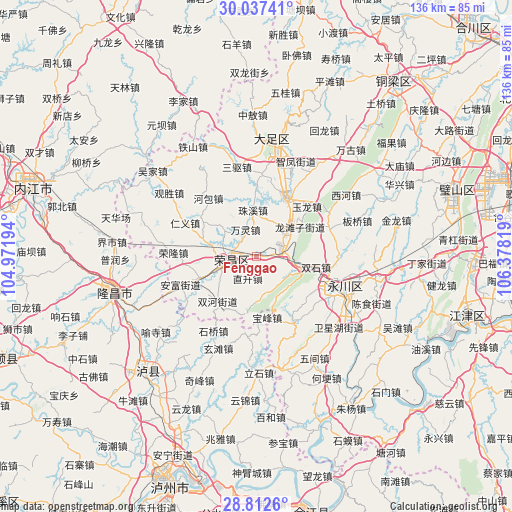
Fenggao GPS coordinates[2]
29° 25' 36.66" North, 105° 40' 30.216" East
| Map corner | latitude | longitude |
|---|---|---|
| Upper-left | 30.03741°, | 104.97194° |
| Center: | 29.42685°, | 105.67506° |
| Lower-right: | 28.8126°, | 106.37819° |
| Map W x H: | 136.2×136.2 km | = 84.6×84.6mi |
| max Lat: | 53.31946° ⇑60.5% North |
| Fenggao: | 29.42685° |
| min Lat: | ⇓39.5% South 18.22056° |
| min Long | Fenggao | max Long |
| 75.07348° | 105.67506° | 134.28917° |
| W 12.1%⇐ | ⇒87.9% E |
Elevation
Elevation of Fenggao is 366 m = 1201 ft, and this is 118.8 m = 390 ft below average elevation for this country.
| Max E: |
5622 m = 18445 ft | 32.6% |
| Avg. | 484.8 m = 1591 ft | |
| Fenggao | 366 m = 1201 ft | |
Min E: |
-3 m = -10 ft | 67.4% |
See also: China elevation on elevation.city.
Geographical zone
Fenggao is located in North temperate zone (between Tropic of Cancer and the Arctic Circle). Distance of this Northern Tropic circle is 666 km =413.8 mi to South.| Distance of | km | miles | from Fenggao |
|---|---|---|---|
| North Pole | 6735.1 | 4185 | to North |
| Arctic Circle | 4129.2 | 2565.8 | to North |
| Tropic Cancer | 666 | 413.8 | to South |
| Equator | 3272 | 2033.1 | to South |


Nearby cities:
15 places around Fenggao: (largest is in red/bold)
• Baofeng
16.5 km =10.3 mi,  169°
169°
• Changyuan
8.8 km =5.5 mi,  253°
253°
• Guangshun
15.5 km =9.6 mi, 248°
• Guchang
10.7 km =6.6 mi,  308°
308°
• Honglu
9.7 km =6 mi,  148°
148°
• Longshi
15.7 km =9.8 mi,  339°
339°
• Longtanzi
14.4 km =8.9 mi,  55°
55°
• Shuanghe
15.6 km =9.7 mi,  220°
220°
• Shuanglu
10.7 km =6.6 mi,  52°
52°
• Shuangshi
16 km =9.9 mi,  100°
100°
• Tongqiao
13.8 km =8.6 mi,  40°
40°
• Yongrong
9.9 km =6.2 mi,  189°
189°
• Youting
6.1 km =3.8 mi,  85°
85°
• Zhisheng
6.3 km =3.9 mi,  199°
199°
• Zhuxi
12.2 km =7.6 mi,  356°
356°
Sources, notices
• [Note1] Compared only with cities in China existing in our database
• [Src1] Map data: © OpenStreetMap contributors (CC-BY-SA)
• [Src2] Other city data from geonames.org with taken over terms of usage.
• [Src3] Geographical zone / Annual Mean Temperature by Robert A. Rohde @ Wikipedia
