Changsheng geodata
Changsheng (Heilongjiang) is a seat of a fourth-order administrative division; located in China in Asia/Shanghai (GMT+8) time zone. In our database, there are 1268 cities with bigger population. Compared to other cities in China, 98.4% of cities are located further ↓South; 95.9% of cities are located further ←West and 60.9% of cities have lower elevation than Changsheng. Note1


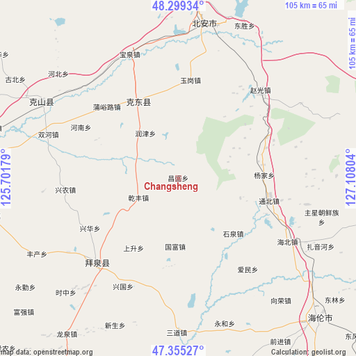
Changsheng GPS coordinates[2]
47° 49' 46.02" North, 126° 24' 17.676" East
| Map corner | latitude | longitude |
|---|---|---|
| Upper-left | 48.29934°, | 125.70179° |
| Center: | 47.82945°, | 126.40491° |
| Lower-right: | 47.35527°, | 127.10804° |
| Map W x H: | 105×105 km | = 65.2×65.2mi |
| max Lat: | 53.31946° ⇑1.6% North |
| Changsheng: | 47.82945° |
| min Lat: | ⇓98.4% South 18.22056° |
| min Long | Changsheng | max Long |
| 75.07348° | 126.40491° | 134.28917° |
| W 95.9%⇐ | ⇒4.1% E |
Elevation
Elevation of Changsheng is 269 m = 883 ft, and this is 215.8 m = 708 ft below average elevation for this country.
| Max E: |
5622 m = 18445 ft | 39.1% |
| Avg. | 484.8 m = 1591 ft | |
| Changsheng | 269 m = 883 ft | |
Min E: |
-3 m = -10 ft | 60.9% |
See also: China elevation on elevation.city.
Geographical zone
Changsheng is located in North temperate zone (between Tropic of Cancer and the Arctic Circle). Distance of this North polar circle is 2083 km =1294.3 mi to North.| Distance of | km | miles | from Changsheng |
|---|---|---|---|
| North Pole | 4688.9 | 2913.5 | to North |
| Arctic Circle | 2083 | 1294.3 | to North |
| Tropic Cancer | 2712.2 | 1685.3 | to South |
| Equator | 5318.1 | 3304.5 | to South |


Nearby cities:
15 places around Changsheng: (largest is in red/bold)
• Aiguo
7 km =4.3 mi,  181°
181°
• Aimin
33.8 km =21 mi,  142°
142°
• Guofu
20.1 km =12.5 mi, 182°
• Henan
32.5 km =20.2 mi,  297°
297°
• Jianguo
24.2 km =15 mi,  267°
267°
• Mingshan
32.3 km =20.1 mi,  337°
337°
• Qianfeng
13.2 km =8.2 mi,  244°
244°
• Runjin
16.4 km =10.2 mi,  323°
323°
• Shangsheng
24.5 km =15.2 mi,  212°
212°
• Shiquan
22.9 km =14.2 mi, 135°
• Shuangqing
14.7 km =9.1 mi,  357°
357°
• Tongbei
27.6 km =17.1 mi,  103°
103°
• Xinghua
30.1 km =18.7 mi, 240°
• Xingnong
33.6 km =20.9 mi,  264°
264°
• Yangjia
25.4 km =15.8 mi,  87°
87°
Sources, notices
• [Note1] Compared only with cities in China existing in our database
• [Src1] Map data: © OpenStreetMap contributors (CC-BY-SA)
• [Src2] Other city data from geonames.org with taken over terms of usage.
• [Src3] Geographical zone / Annual Mean Temperature by Robert A. Rohde @ Wikipedia
