Guofu geodata
Guofu (Heilongjiang) is a seat of a fourth-order administrative division; located in China in Asia/Shanghai (GMT+8) time zone. In our database, there are 1268 cities with bigger population. Compared to other cities in China, 98.1% of cities are located further ↓South; 95.9% of cities are located further ←West and 59.9% of cities have lower elevation than Guofu. Note1


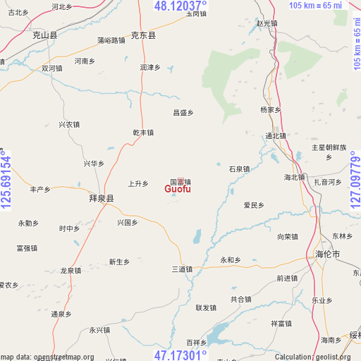
Guofu GPS coordinates[2]
47° 38' 55.824" North, 126° 23' 40.776" East
| Map corner | latitude | longitude |
|---|---|---|
| Upper-left | 48.12037°, | 125.69154° |
| Center: | 47.64884°, | 126.39466° |
| Lower-right: | 47.17301°, | 127.09779° |
| Map W x H: | 105.3×105.3 km | = 65.4×65.4mi |
| max Lat: | 53.31946° ⇑1.9% North |
| Guofu: | 47.64884° |
| min Lat: | ⇓98.1% South 18.22056° |
| min Long | Guofu | max Long |
| 75.07348° | 126.39466° | 134.28917° |
| W 95.9%⇐ | ⇒4.1% E |
Elevation
Elevation of Guofu is 258 m = 846 ft, and this is 226.8 m = 744 ft below average elevation for this country.
| Max E: |
5622 m = 18445 ft | 40.1% |
| Avg. | 484.8 m = 1591 ft | |
| Guofu | 258 m = 846 ft | |
Min E: |
-3 m = -10 ft | 59.9% |
See also: China elevation on elevation.city.
Geographical zone
Guofu is located in North temperate zone (between Tropic of Cancer and the Arctic Circle). Distance of this North polar circle is 2103.1 km =1306.8 mi to North.| Distance of | km | miles | from Guofu |
|---|---|---|---|
| North Pole | 4709 | 2926 | to North |
| Arctic Circle | 2103.1 | 1306.8 | to North |
| Tropic Cancer | 2692.1 | 1672.8 | to South |
| Equator | 5298.1 | 3292.1 | to South |


Nearby cities:
15 places around Guofu: (largest is in red/bold)
• Aiguo
13.1 km =8.1 mi,  2°
2°
• Aimin
22.4 km =13.9 mi,  107°
107°
• Baiquan
23.7 km =14.7 mi,  258°
258°
• Changsheng
20.1 km =12.5 mi, 2°
• Huaguang
14.1 km =8.8 mi,  171°
171°
• Jianguo
30.2 km =18.8 mi,  309°
309°
• Minle
30 km =18.6 mi,  242°
242°
• Qianfeng
18.1 km =11.2 mi,  322°
322°
• Sandao
25.7 km =16 mi,  179°
179°
• Shangsheng
12.5 km =7.8 mi,  267°
267°
• Shiquan
17.3 km =10.7 mi,  77°
77°
• Xingguo
20 km =12.4 mi,  232°
232°
• Xinghua
26.1 km =16.2 mi,  281°
281°
• Xinsheng
29.4 km =18.3 mi,  217°
217°
• Yonghe
27.1 km =16.8 mi,  147°
147°
Sources, notices
• [Note1] Compared only with cities in China existing in our database
• [Src1] Map data: © OpenStreetMap contributors (CC-BY-SA)
• [Src2] Other city data from geonames.org with taken over terms of usage.
• [Src3] Geographical zone / Annual Mean Temperature by Robert A. Rohde @ Wikipedia
