Yonghe geodata
Yonghe (Heilongjiang) is a seat of a fourth-order administrative division; located in China in Asia/Shanghai (GMT+8) time zone. In our database, there are 1268 cities with bigger population. Compared to other cities in China, 97.8% of cities are located further ↓South; 96.1% of cities are located further ←West and 53.2% of cities have lower elevation than Yonghe. Note1


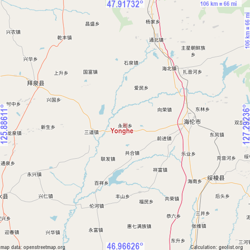
Yonghe GPS coordinates[2]
47° 26' 38.184" North, 126° 35' 21.228" East
| Map corner | latitude | longitude |
|---|---|---|
| Upper-left | 47.91732°, | 125.88611° |
| Center: | 47.44394°, | 126.58923° |
| Lower-right: | 46.96626°, | 127.29236° |
| Map W x H: | 105.7×105.7 km | = 65.7×65.7mi |
| max Lat: | 53.31946° ⇑2.2% North |
| Yonghe: | 47.44394° |
| min Lat: | ⇓97.8% South 18.22056° |
| min Long | Yonghe | max Long |
| 75.07348° | 126.58923° | 134.28917° |
| W 96.1%⇐ | ⇒3.9% E |
Elevation
Elevation of Yonghe is 190 m = 623 ft, and this is 294.8 m = 967 ft below average elevation for this country.
| Max E: |
5622 m = 18445 ft | 46.8% |
| Avg. | 484.8 m = 1591 ft | |
| Yonghe | 190 m = 623 ft | |
Min E: |
-3 m = -10 ft | 53.2% |
See also: China elevation on elevation.city.
Geographical zone
Yonghe is located in North temperate zone (between Tropic of Cancer and the Arctic Circle). Distance of this North polar circle is 2125.9 km =1321 mi to North.| Distance of | km | miles | from Yonghe |
|---|---|---|---|
| North Pole | 4731.8 | 2940.2 | to North |
| Arctic Circle | 2125.9 | 1321 | to North |
| Tropic Cancer | 2669.4 | 1658.7 | to South |
| Equator | 5275.3 | 3277.9 | to South |


Nearby cities:
15 places around Yonghe: (largest is in red/bold)
• Aimin
17.4 km =10.8 mi,  23°
23°
• Baixiang
26.6 km =16.5 mi,  202°
202°
• Changfa
27.5 km =17.1 mi,  70°
70°
• Gonghe
11.8 km =7.3 mi,  166°
166°
• Guangrong
24.7 km =15.3 mi,  235°
235°
• Guofu
27.1 km =16.8 mi,  327°
327°
• Hailun
27.4 km =17 mi,  87°
87°
• Haixing
29 km =18 mi, 167°
• Huaguang
15.4 km =9.6 mi,  304°
304°
• Lianfa
15.9 km =9.9 mi,  208°
208°
• Qianjin
17.6 km =10.9 mi,  107°
107°
• Sandao
14.5 km =9 mi,  258°
258°
• Shiquan
26.6 km =16.5 mi,  4°
4°
• Xiangfu
23.7 km =14.7 mi,  142°
142°
• Xiangrong
18.5 km =11.5 mi, 66°
Sources, notices
• [Note1] Compared only with cities in China existing in our database
• [Src1] Map data: © OpenStreetMap contributors (CC-BY-SA)
• [Src2] Other city data from geonames.org with taken over terms of usage.
• [Src3] Geographical zone / Annual Mean Temperature by Robert A. Rohde @ Wikipedia
