Xinyan geodata
Xinyan (Hubei) is a seat of a fourth-order administrative division; located in China in Asia/Shanghai (GMT+8) time zone. In our database, there are 1268 cities with bigger population. Compared to other cities in China, 52.2% of cities are located further ↓South; 54.3% of cities are located further →East and 79.8% of cities have higher elevation than Xinyan. Note1


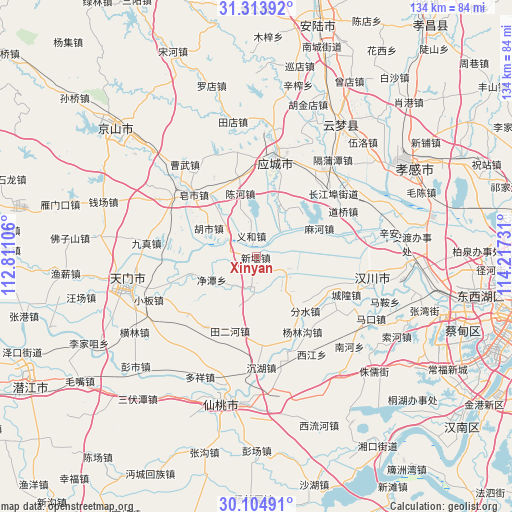
Xinyan GPS coordinates[2]
30° 42' 40.716" North, 113° 30' 51.048" East
| Map corner | latitude | longitude |
|---|---|---|
| Upper-left | 31.31392°, | 112.81106° |
| Center: | 30.71131°, | 113.51418° |
| Lower-right: | 30.10491°, | 114.21731° |
| Map W x H: | 134.4×134.4 km | = 83.5×83.5mi |
| max Lat: | 53.31946° ⇑47.8% North |
| Xinyan: | 30.71131° |
| min Lat: | ⇓52.2% South 18.22056° |
| min Long | Xinyan | max Long |
| 75.07348° | 113.51418° | 134.28917° |
| W 45.7%⇐ | ⇒54.3% E |
Elevation
Elevation of Xinyan is 27 m = 89 ft, and this is 457.8 m = 1502 ft below average elevation for this country.
| Max E: |
5622 m = 18445 ft | 79.8% |
| Avg. | 484.8 m = 1591 ft | |
| Xinyan | 27 m = 89 ft | |
Min E: |
-3 m = -10 ft | 20.2% |
See also: China elevation on elevation.city.
Geographical zone
Xinyan is located in North temperate zone (between Tropic of Cancer and the Arctic Circle). Distance of this Northern Tropic circle is 808.9 km =502.6 mi to South.| Distance of | km | miles | from Xinyan |
|---|---|---|---|
| North Pole | 6592.3 | 4096.3 | to North |
| Arctic Circle | 3986.4 | 2477 | to North |
| Tropic Cancer | 808.9 | 502.6 | to South |
| Equator | 3414.8 | 2121.9 | to South |


Nearby cities:
15 places around Xinyan: (largest is in red/bold)
• Chenhe
17.2 km =10.7 mi,  346°
346°
• Dongzhong
10.6 km =6.6 mi,  311°
311°
• Fenshui
19.2 km =11.9 mi,  137°
137°
• Hanji
9.5 km =5.9 mi,  117°
117°
• Hushi
14.3 km =8.9 mi,  300°
300°
• Jingtan
13.3 km =8.3 mi,  242°
242°
• Litan
15.3 km =9.5 mi,  162°
162°
• Liuhe
17.1 km =10.6 mi,  317°
317°
• Lushi
17.7 km =11 mi,  253°
253°
• Mahe
18.3 km =11.4 mi,  65°
65°
• Sihe
19 km =11.8 mi,  274°
274°
• Tian’e
9.4 km =5.8 mi,  41°
41°
• Tian’erhe
20.7 km =12.9 mi,  199°
199°
• Wantan
21.3 km =13.2 mi,  132°
132°
• Yihe
5 km =3.1 mi, 350°
Sources, notices
• [Note1] Compared only with cities in China existing in our database
• [Src1] Map data: © OpenStreetMap contributors (CC-BY-SA)
• [Src2] Other city data from geonames.org with taken over terms of usage.
• [Src3] Geographical zone / Annual Mean Temperature by Robert A. Rohde @ Wikipedia
