Mahe geodata
Mahe (Hubei) is a seat of a fourth-order administrative division; located in China in Asia/Shanghai (GMT+8) time zone. In our database, there are 1268 cities with bigger population. Compared to other cities in China, 52.8% of cities are located further ↓South; 53.1% of cities are located further →East and 77.7% of cities have higher elevation than Mahe. Note1


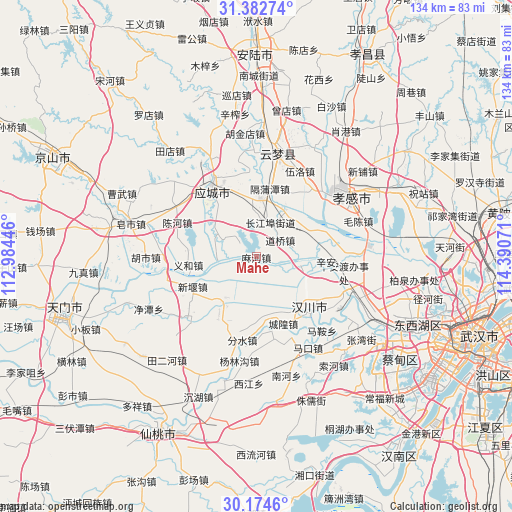
Mahe GPS coordinates[2]
30° 46' 50.052" North, 113° 41' 15.288" East
| Map corner | latitude | longitude |
|---|---|---|
| Upper-left | 31.38274°, | 112.98446° |
| Center: | 30.78057°, | 113.68758° |
| Lower-right: | 30.1746°, | 114.39071° |
| Map W x H: | 134.3×134.3 km | = 83.5×83.5mi |
| max Lat: | 53.31946° ⇑47.2% North |
| Mahe: | 30.78057° |
| min Lat: | ⇓52.8% South 18.22056° |
| min Long | Mahe | max Long |
| 75.07348° | 113.68758° | 134.28917° |
| W 46.9%⇐ | ⇒53.1% E |
Elevation
Elevation of Mahe is 31 m = 102 ft, and this is 453.8 m = 1489 ft below average elevation for this country.
| Max E: |
5622 m = 18445 ft | 77.7% |
| Avg. | 484.8 m = 1591 ft | |
| Mahe | 31 m = 102 ft | |
Min E: |
-3 m = -10 ft | 22.3% |
See also: China elevation on elevation.city.
Geographical zone
Mahe is located in North temperate zone (between Tropic of Cancer and the Arctic Circle). Distance of this Northern Tropic circle is 816.6 km =507.4 mi to South.| Distance of | km | miles | from Mahe |
|---|---|---|---|
| North Pole | 6584.6 | 4091.5 | to North |
| Arctic Circle | 3978.7 | 2472.2 | to North |
| Tropic Cancer | 816.6 | 507.4 | to South |
| Equator | 3422.5 | 2126.6 | to South |


Nearby cities:
15 places around Mahe: (largest is in red/bold)
• Changjiangbu
9.7 km =6 mi,  22°
22°
• Daoqiao
7.6 km =4.7 mi,  55°
55°
• Dongmafang
15.4 km =9.6 mi,  2°
2°
• Geputan
18.1 km =11.2 mi,  11°
11°
• Hanchuan
16.4 km =10.2 mi,  152°
152°
• Hanji
14.6 km =9.1 mi,  214°
214°
• Huangtan
17.6 km =10.9 mi,  320°
320°
• Huzhen
14.3 km =8.9 mi,  31°
31°
• Langjun
13.2 km =8.2 mi,  353°
353°
• Langjun
15.1 km =9.4 mi,  343°
343°
• Liujiage
11.8 km =7.3 mi,  102°
102°
• Tian’e
10.4 km =6.5 mi,  266°
266°
• Xiaxindian
15.3 km =9.5 mi,  67°
67°
• Xinyan
18.3 km =11.4 mi,  245°
245°
• Yihe
17.6 km =10.9 mi,  260°
260°
Sources, notices
• [Note1] Compared only with cities in China existing in our database
• [Src1] Map data: © OpenStreetMap contributors (CC-BY-SA)
• [Src2] Other city data from geonames.org with taken over terms of usage.
• [Src3] Geographical zone / Annual Mean Temperature by Robert A. Rohde @ Wikipedia
