Dayong geodata
Dayong (Heilongjiang) is a seat of a fourth-order administrative division; located in China in Asia/Shanghai (GMT+8) time zone. In our database, there are 1268 cities with bigger population. Compared to other cities in China, 95.5% of cities are located further ↓South; 96.3% of cities are located further ←West and 52.9% of cities have higher elevation than Dayong. Note1


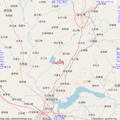
Dayong GPS coordinates[2]
46° 17' 2.652" North, 126° 42' 54.9" East
| Map corner | latitude | longitude |
|---|---|---|
| Upper-left | 46.76783°, | 126.01213° |
| Center: | 46.28407°, | 126.71525° |
| Lower-right: | 45.796°, | 127.41838° |
| Map W x H: | 108.1×108.1 km | = 67.2×67.2mi |
| max Lat: | 53.31946° ⇑4.5% North |
| Dayong: | 46.28407° |
| min Lat: | ⇓95.5% South 18.22056° |
| min Long | Dayong | max Long |
| 75.07348° | 126.71525° | 134.28917° |
| W 96.3%⇐ | ⇒3.7% E |
Elevation
Elevation of Dayong is 144 m = 472 ft, and this is 340.8 m = 1118 ft below average elevation for this country.
| Max E: |
5622 m = 18445 ft | 52.9% |
| Avg. | 484.8 m = 1591 ft | |
| Dayong | 144 m = 472 ft | |
Min E: |
-3 m = -10 ft | 47.1% |
See also: China elevation on elevation.city.
Geographical zone
Dayong is located in North temperate zone (between Tropic of Cancer and the Arctic Circle). Distance of this North polar circle is 2254.9 km =1401.1 mi to North.| Distance of | km | miles | from Dayong |
|---|---|---|---|
| North Pole | 4860.8 | 3020.4 | to North |
| Arctic Circle | 2254.9 | 1401.1 | to North |
| Tropic Cancer | 2540.4 | 1578.5 | to South |
| Equator | 5146.3 | 3197.8 | to South |


Nearby cities:
15 places around Dayong: (largest is in red/bold)
• Baikui
23.4 km =14.5 mi,  67°
67°
• Changgang
22.7 km =14.1 mi,  287°
287°
• Changjiang
15 km =9.3 mi,  277°
277°
• Changling
27 km =16.8 mi,  192°
192°
• Fangtai
27.4 km =17 mi,  142°
142°
• Hongguang
24.8 km =15.4 mi,  51°
51°
• Hongqi
26.6 km =16.5 mi,  335°
335°
• Kangjin
11.8 km =7.3 mi, 144°
• Lanhe
22.4 km =13.9 mi,  249°
249°
• Lianhua
7.7 km =4.8 mi,  40°
40°
• Linjiang
25.9 km =16.1 mi,  312°
312°
• Shenjia
21.6 km =13.4 mi,  169°
169°
• Shiren
13.5 km =8.4 mi,  85°
85°
• Xichangfa
15.6 km =9.7 mi,  353°
353°
• Xubao
13.7 km =8.5 mi, 191°
Sources, notices
• [Note1] Compared only with cities in China existing in our database
• [Src1] Map data: © OpenStreetMap contributors (CC-BY-SA)
• [Src2] Other city data from geonames.org with taken over terms of usage.
• [Src3] Geographical zone / Annual Mean Temperature by Robert A. Rohde @ Wikipedia
