Dongshan geodata
Dongshan (Heilongjiang) is a seat of a third-order administrative division; located in China in Asia/Shanghai (GMT+8) time zone. In our database, there are 1268 cities with bigger population. Compared to other cities in China, 97.7% of cities are located further ↓South; 99.4% of cities are located further ←West and 50.4% of cities have higher elevation than Dongshan. Note1


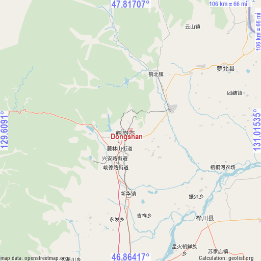
Dongshan GPS coordinates[2]
47° 20' 33.972" North, 130° 18' 43.992" East
| Map corner | latitude | longitude |
|---|---|---|
| Upper-left | 47.81707°, | 129.6091° |
| Center: | 47.34277°, | 130.31222° |
| Lower-right: | 46.86417°, | 131.01535° |
| Map W x H: | 106×106 km | = 65.9×65.9mi |
| max Lat: | 53.31946° ⇑2.3% North |
| Dongshan: | 47.34277° |
| min Lat: | ⇓97.7% South 18.22056° |
| min Long | Dongshan | max Long |
| 75.07348° | 130.31222° | 134.28917° |
| W 99.4%⇐ | ⇒0.59999999999999% E |
Elevation
Elevation of Dongshan is 161 m = 528 ft, and this is 323.8 m = 1062 ft below average elevation for this country.
| Max E: |
5622 m = 18445 ft | 50.4% |
| Avg. | 484.8 m = 1591 ft | |
| Dongshan | 161 m = 528 ft | |
Min E: |
-3 m = -10 ft | 49.6% |
See also: China elevation on elevation.city.
Geographical zone
Dongshan is located in North temperate zone (between Tropic of Cancer and the Arctic Circle). Distance of this North polar circle is 2137.2 km =1328 mi to North.| Distance of | km | miles | from Dongshan |
|---|---|---|---|
| North Pole | 4743 | 2947.2 | to North |
| Arctic Circle | 2137.2 | 1328 | to North |
| Tropic Cancer | 2658.1 | 1651.7 | to South |
| Equator | 5264 | 3270.9 | to South |


Nearby cities:
15 places around Dongshan: (largest is in red/bold)
• Dongfanghong
1.8 km =1.1 mi,  130°
130°
• Gounan
2.2 km =1.4 mi,  329°
329°
• Guangming
1.9 km =1.2 mi,  259°
259°
• Hebei
25.4 km =15.8 mi,  23°
23°
• Hegang
1.3 km =0.8 mi,  315°
315°
• Heli
32 km =19.9 mi,  184°
184°
• Hongqi
4.3 km =2.7 mi,  230°
230°
• Hongqi
14.9 km =9.3 mi,  217°
217°
• Jixiang
35.1 km =21.8 mi,  170°
170°
• Shuyuan
3.3 km =2.1 mi, 255°
• Tiexi
4.2 km =2.6 mi, 215°
• Xing’an
12.8 km =8 mi,  212°
212°
• Xinhua
25.6 km =15.9 mi, 182°
• Yongfa
36.2 km =22.5 mi,  188°
188°
• Zhenxing
37.7 km =23.4 mi,  135°
135°
Sources, notices
• [Note1] Compared only with cities in China existing in our database
• [Src1] Map data: © OpenStreetMap contributors (CC-BY-SA)
• [Src2] Other city data from geonames.org with taken over terms of usage.
• [Src3] Geographical zone / Annual Mean Temperature by Robert A. Rohde @ Wikipedia
