Zhenxing geodata
Zhenxing (Heilongjiang) is a seat of a fourth-order administrative division; located in China in Asia/Shanghai (GMT+8) time zone. In our database, there are 1268 cities with bigger population. Compared to other cities in China, 97.1% of cities are located further ↓South; 99.7% of cities are located further ←West and 64.9% of cities have higher elevation than Zhenxing. Note1


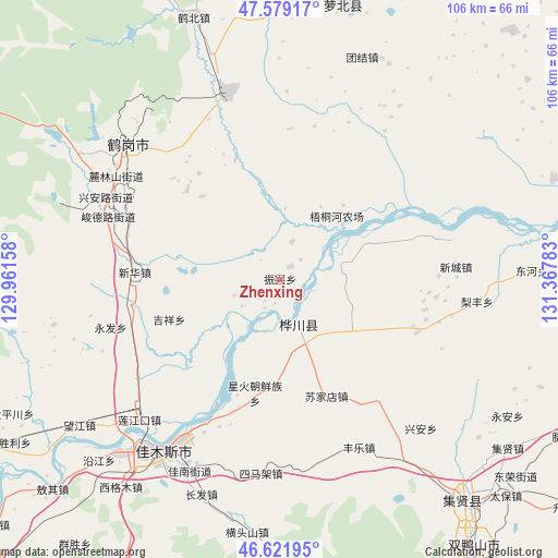
Zhenxing GPS coordinates[2]
47° 6' 9.756" North, 130° 39' 52.92" East
| Map corner | latitude | longitude |
|---|---|---|
| Upper-left | 47.57917°, | 129.96158° |
| Center: | 47.10271°, | 130.6647° |
| Lower-right: | 46.62195°, | 131.36783° |
| Map W x H: | 106.4×106.4 km | = 66.1×66.1mi |
| max Lat: | 53.31946° ⇑2.9% North |
| Zhenxing: | 47.10271° |
| min Lat: | ⇓97.1% South 18.22056° |
| min Long | Zhenxing | max Long |
| 75.07348° | 130.6647° | 134.28917° |
| W 99.7%⇐ | ⇒0.3% E |
Elevation
Elevation of Zhenxing is 73 m = 240 ft, and this is 411.8 m = 1351 ft below average elevation for this country.
| Max E: |
5622 m = 18445 ft | 64.9% |
| Avg. | 484.8 m = 1591 ft | |
| Zhenxing | 73 m = 240 ft | |
Min E: |
-3 m = -10 ft | 35.1% |
See also: China elevation on elevation.city.
Geographical zone
Zhenxing is located in North temperate zone (between Tropic of Cancer and the Arctic Circle). Distance of this North polar circle is 2163.8 km =1344.5 mi to North.| Distance of | km | miles | from Zhenxing |
|---|---|---|---|
| North Pole | 4769.7 | 2963.8 | to North |
| Arctic Circle | 2163.8 | 1344.5 | to North |
| Tropic Cancer | 2631.4 | 1635.1 | to South |
| Equator | 5237.3 | 3254.3 | to South |


Nearby cities:
15 places around Zhenxing: (largest is in red/bold)
• Chuangye
20.8 km =12.9 mi,  184°
184°
• Dongfanghong
35.9 km =22.3 mi,  315°
315°
• Fengle
35.4 km =22 mi,  154°
154°
• Heli
29.5 km =18.3 mi,  259°
259°
• Jianguo
26.7 km =16.6 mi,  199°
199°
• Jixiang
22.2 km =13.8 mi,  249°
249°
• Ping’an
36.3 km =22.6 mi,  226°
226°
• Simajia
37.1 km =23.1 mi,  185°
185°
• Songjiang
34.7 km =21.6 mi,  210°
210°
• Sujiadian
23.9 km =14.9 mi,  158°
158°
• Xinghuo
21.8 km =13.5 mi, 192°
• Xing’an
37.2 km =23.1 mi,  295°
295°
• Xinhua
27.9 km =17.3 mi,  272°
272°
• Yongfa
33.5 km =20.8 mi, 254°
• Yuelai
9.6 km =6 mi, 157°
Sources, notices
• [Note1] Compared only with cities in China existing in our database
• [Src1] Map data: © OpenStreetMap contributors (CC-BY-SA)
• [Src2] Other city data from geonames.org with taken over terms of usage.
• [Src3] Geographical zone / Annual Mean Temperature by Robert A. Rohde @ Wikipedia
