Hebei geodata
Hebei (Heilongjiang) is a seat of a fourth-order administrative division; located in China in Asia/Shanghai (GMT+8) time zone. In our database, there are 1268 cities with bigger population. Compared to other cities in China, 98% of cities are located further ↓South; 99.5% of cities are located further ←West and 56.4% of cities have higher elevation than Hebei. Note1


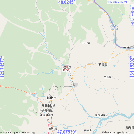
Hebei GPS coordinates[2]
47° 33' 7.524" North, 130° 26' 56.004" East
| Map corner | latitude | longitude |
|---|---|---|
| Upper-left | 48.0245°, | 129.74577° |
| Center: | 47.55209°, | 130.44889° |
| Lower-right: | 47.07539°, | 131.15202° |
| Map W x H: | 105.5×105.5 km | = 65.6×65.6mi |
| max Lat: | 53.31946° ⇑2% North |
| Hebei: | 47.55209° |
| min Lat: | ⇓98% South 18.22056° |
| min Long | Hebei | max Long |
| 75.07348° | 130.44889° | 134.28917° |
| W 99.5%⇐ | ⇒0.5% E |
Elevation
Elevation of Hebei is 121 m = 397 ft, and this is 363.8 m = 1194 ft below average elevation for this country.
| Max E: |
5622 m = 18445 ft | 56.4% |
| Avg. | 484.8 m = 1591 ft | |
| Hebei | 121 m = 397 ft | |
Min E: |
-3 m = -10 ft | 43.6% |
See also: China elevation on elevation.city.
Geographical zone
Hebei is located in North temperate zone (between Tropic of Cancer and the Arctic Circle). Distance of this North polar circle is 2113.9 km =1313.5 mi to North.| Distance of | km | miles | from Hebei |
|---|---|---|---|
| North Pole | 4719.8 | 2932.7 | to North |
| Arctic Circle | 2113.9 | 1313.5 | to North |
| Tropic Cancer | 2681.4 | 1666.1 | to South |
| Equator | 5287.3 | 3285.4 | to South |


Nearby cities:
15 places around Hebei: (largest is in red/bold)
• Dongfanghong
26 km =16.2 mi,  199°
199°
• Dongming
29.5 km =18.3 mi,  85°
85°
• Dongshan
25.4 km =15.8 mi, 203°
• Fengxiang
28.2 km =17.5 mi,  84°
84°
• Gounan
24.3 km =15.1 mi,  207°
207°
• Guangming
26.6 km =16.5 mi, 207°
• Hegang
25 km =15.5 mi, 206°
• Hongqi
29.4 km =18.3 mi, 207°
• Hongqi
40 km =24.9 mi, 209°
• Huanshan
24.2 km =15 mi,  37°
37°
• Mingshan
48.8 km =30.3 mi,  73°
73°
• Shuyuan
27.6 km =17.1 mi, 209°
• Tiexi
29.6 km =18.4 mi, 205°
• Tuanjie
32.6 km =20.3 mi,  103°
103°
• Xing’an
38.1 km =23.7 mi, 206°
Sources, notices
• [Note1] Compared only with cities in China existing in our database
• [Src1] Map data: © OpenStreetMap contributors (CC-BY-SA)
• [Src2] Other city data from geonames.org with taken over terms of usage.
• [Src3] Geographical zone / Annual Mean Temperature by Robert A. Rohde @ Wikipedia
