Jubaoshan geodata
Jubaoshan (Heilongjiang) is a seat of a fourth-order administrative division; located in China in Asia/Shanghai (GMT+8) time zone. In our database, there are 1268 cities with bigger population. Compared to other cities in China, 96.2% of cities are located further ↓South; 97.6% of cities are located further ←West and 56.3% of cities have lower elevation than Jubaoshan. Note1


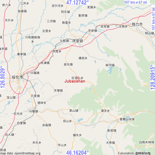
Jubaoshan GPS coordinates[2]
46° 38' 48.768" North, 127° 30' 21.672" East
| Map corner | latitude | longitude |
|---|---|---|
| Upper-left | 47.12742°, | 126.8029° |
| Center: | 46.64688°, | 127.50602° |
| Lower-right: | 46.16204°, | 128.20915° |
| Map W x H: | 107.3×107.3 km | = 66.7×66.7mi |
| max Lat: | 53.31946° ⇑3.8% North |
| Jubaoshan: | 46.64688° |
| min Lat: | ⇓96.2% South 18.22056° |
| min Long | Jubaoshan | max Long |
| 75.07348° | 127.50602° | 134.28917° |
| W 97.6%⇐ | ⇒2.4% E |
Elevation
Elevation of Jubaoshan is 219 m = 719 ft, and this is 265.8 m = 872 ft below average elevation for this country.
| Max E: |
5622 m = 18445 ft | 43.7% |
| Avg. | 484.8 m = 1591 ft | |
| Jubaoshan | 219 m = 719 ft | |
Min E: |
-3 m = -10 ft | 56.3% |
See also: China elevation on elevation.city.
Geographical zone
Jubaoshan is located in North temperate zone (between Tropic of Cancer and the Arctic Circle). Distance of this North polar circle is 2214.5 km =1376 mi to North.| Distance of | km | miles | from Jubaoshan |
|---|---|---|---|
| North Pole | 4820.4 | 2995.3 | to North |
| Arctic Circle | 2214.5 | 1376 | to North |
| Tropic Cancer | 2580.7 | 1603.6 | to South |
| Equator | 5186.6 | 3222.8 | to South |


Nearby cities:
15 places around Jubaoshan: (largest is in red/bold)
• Daluo
5.7 km =3.5 mi,  117°
117°
• Dexiang
30.1 km =18.7 mi,  234°
234°
• Dongjin
24.9 km =15.5 mi,  294°
294°
• Fengshou
26 km =16.2 mi,  12°
12°
• Heishan
22.9 km =14.2 mi,  186°
186°
• Huansheng
23.2 km =14.4 mi,  322°
322°
• Jianmin
14 km =8.7 mi, 14°
• Jinhe
28.7 km =17.8 mi, 290°
• Jiusheng
27.4 km =17 mi,  340°
340°
• Longtai
22.3 km =13.9 mi,  281°
281°
• Minle
11.3 km =7 mi, 324°
• Qing’an
25.7 km =16 mi,  359°
359°
• Shanhou
10.2 km =6.3 mi, 231°
• Xingfu
29.9 km =18.6 mi, 276°
• Xinsheng
19.7 km =12.2 mi,  50°
50°
Sources, notices
• [Note1] Compared only with cities in China existing in our database
• [Src1] Map data: © OpenStreetMap contributors (CC-BY-SA)
• [Src2] Other city data from geonames.org with taken over terms of usage.
• [Src3] Geographical zone / Annual Mean Temperature by Robert A. Rohde @ Wikipedia
