Dexiang geodata
Dexiang (Heilongjiang) is a seat of a fourth-order administrative division; located in China in Asia/Shanghai (GMT+8) time zone. In our database, there are 1268 cities with bigger population. Compared to other cities in China, 95.9% of cities are located further ↓South; 97% of cities are located further ←West and 54.3% of cities have lower elevation than Dexiang. Note1


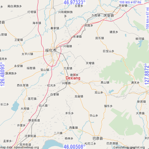
Dexiang GPS coordinates[2]
46° 29' 28.716" North, 127° 11' 2.652" East
| Map corner | latitude | longitude |
|---|---|---|
| Upper-left | 46.97323°, | 126.48095° |
| Center: | 46.49131°, | 127.18407° |
| Lower-right: | 46.00508°, | 127.8872° |
| Map W x H: | 107.6×107.6 km | = 66.9×66.9mi |
| max Lat: | 53.31946° ⇑4.1% North |
| Dexiang: | 46.49131° |
| min Lat: | ⇓95.9% South 18.22056° |
| min Long | Dexiang | max Long |
| 75.07348° | 127.18407° | 134.28917° |
| W 97%⇐ | ⇒3% E |
Elevation
Elevation of Dexiang is 200 m = 656 ft, and this is 284.8 m = 934 ft below average elevation for this country.
| Max E: |
5622 m = 18445 ft | 45.7% |
| Avg. | 484.8 m = 1591 ft | |
| Dexiang | 200 m = 656 ft | |
Min E: |
-3 m = -10 ft | 54.3% |
See also: China elevation on elevation.city.
Geographical zone
Dexiang is located in North temperate zone (between Tropic of Cancer and the Arctic Circle). Distance of this North polar circle is 2231.8 km =1386.8 mi to North.| Distance of | km | miles | from Dexiang |
|---|---|---|---|
| North Pole | 4837.7 | 3006 | to North |
| Arctic Circle | 2231.8 | 1386.8 | to North |
| Tropic Cancer | 2563.4 | 1592.8 | to South |
| Equator | 5169.3 | 3212.1 | to South |


Nearby cities:
15 places around Dexiang: (largest is in red/bold)
• Baikui
20.2 km =12.6 mi,  225°
225°
• Baoshan
21.7 km =13.5 mi,  280°
280°
• Dayou
22 km =13.7 mi,  316°
316°
• Dongfu
23.1 km =14.4 mi,  325°
325°
• Heishan
22.5 km =14 mi,  103°
103°
• Hongguang
18.2 km =11.3 mi,  245°
245°
• Jinhe
27.3 km =17 mi,  354°
354°
• Longmiao
15.9 km =9.9 mi,  167°
167°
• Longtai
21.9 km =13.6 mi,  7°
7°
• Shanhou
19.9 km =12.4 mi,  56°
56°
• Suihua
21.9 km =13.6 mi, 318°
• Wanfa
6.8 km =4.2 mi,  314°
314°
• Waxing
27.1 km =16.8 mi,  123°
123°
• Xingfu
21.5 km =13.4 mi, 346°
• Xinglong
8.5 km =5.3 mi, 228°
Sources, notices
• [Note1] Compared only with cities in China existing in our database
• [Src1] Map data: © OpenStreetMap contributors (CC-BY-SA)
• [Src2] Other city data from geonames.org with taken over terms of usage.
• [Src3] Geographical zone / Annual Mean Temperature by Robert A. Rohde @ Wikipedia
