Zhifu geodata
Zhifu (Heilongjiang) is a seat of a fourth-order administrative division; located in China in Asia/Shanghai (GMT+8) time zone. In our database, there are 1268 cities with bigger population. Compared to other cities in China, 96.9% of cities are located further ↓South; 97.4% of cities are located further ←West and 52.1% of cities have lower elevation than Zhifu. Note1


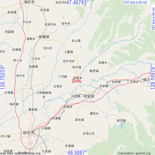
Zhifu GPS coordinates[2]
46° 59' 25.692" North, 127° 24' 20.34" East
| Map corner | latitude | longitude |
|---|---|---|
| Upper-left | 47.46793°, | 126.70253° |
| Center: | 46.99047°, | 127.40565° |
| Lower-right: | 46.5087°, | 128.10878° |
| Map W x H: | 106.7×106.7 km | = 66.3×66.3mi |
| max Lat: | 53.31946° ⇑3.1% North |
| Zhifu: | 46.99047° |
| min Lat: | ⇓96.9% South 18.22056° |
| min Long | Zhifu | max Long |
| 75.07348° | 127.40565° | 134.28917° |
| W 97.4%⇐ | ⇒2.6% E |
Elevation
Elevation of Zhifu is 182 m = 597 ft, and this is 302.8 m = 993 ft below average elevation for this country.
| Max E: |
5622 m = 18445 ft | 47.9% |
| Avg. | 484.8 m = 1591 ft | |
| Zhifu | 182 m = 597 ft | |
Min E: |
-3 m = -10 ft | 52.1% |
See also: China elevation on elevation.city.
Geographical zone
Zhifu is located in North temperate zone (between Tropic of Cancer and the Arctic Circle). Distance of this North polar circle is 2176.3 km =1352.3 mi to North.| Distance of | km | miles | from Zhifu |
|---|---|---|---|
| North Pole | 4782.2 | 2971.5 | to North |
| Arctic Circle | 2176.3 | 1352.3 | to North |
| Tropic Cancer | 2618.9 | 1627.3 | to South |
| Equator | 5224.9 | 3246.6 | to South |


Nearby cities:
15 places around Zhifu: (largest is in red/bold)
• Changshan
25.3 km =15.7 mi,  356°
356°
• Fazhan
20.3 km =12.6 mi,  58°
58°
• Fengshou
18.6 km =11.6 mi,  133°
133°
• Huansheng
20.9 km =13 mi,  197°
197°
• Jiusheng
12.6 km =7.8 mi,  187°
187°
• Ping’an
18.6 km =11.6 mi,  107°
107°
• Qing’an
14.5 km =9 mi,  150°
150°
• Qinlao
12.3 km =7.6 mi,  67°
67°
• Sanhe
9.4 km =5.8 mi,  277°
277°
• Shangji
19.1 km =11.9 mi,  340°
340°
• Shuangfeng
26.4 km =16.4 mi,  95°
95°
• Shuanghe
21.7 km =13.5 mi,  236°
236°
• Tongle
7.4 km =4.6 mi,  353°
353°
• Wuying
14.7 km =9.1 mi,  246°
246°
• Xinghe
26 km =16.2 mi, 243°
Sources, notices
• [Note1] Compared only with cities in China existing in our database
• [Src1] Map data: © OpenStreetMap contributors (CC-BY-SA)
• [Src2] Other city data from geonames.org with taken over terms of usage.
• [Src3] Geographical zone / Annual Mean Temperature by Robert A. Rohde @ Wikipedia
