Fazhan geodata
Fazhan (Heilongjiang) is a seat of a fourth-order administrative division; located in China in Asia/Shanghai (GMT+8) time zone. In our database, there are 1268 cities with bigger population. Compared to other cities in China, 97.1% of cities are located further ↓South; 97.7% of cities are located further ←West and 55.8% of cities have lower elevation than Fazhan. Note1


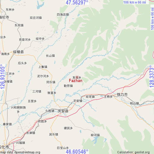
Fazhan GPS coordinates[2]
47° 5' 10.932" North, 127° 38' 3.012" East
| Map corner | latitude | longitude |
|---|---|---|
| Upper-left | 47.56297°, | 126.93105° |
| Center: | 47.08637°, | 127.63417° |
| Lower-right: | 46.60546°, | 128.3373° |
| Map W x H: | 106.5×106.5 km | = 66.2×66.2mi |
| max Lat: | 53.31946° ⇑2.9% North |
| Fazhan: | 47.08637° |
| min Lat: | ⇓97.1% South 18.22056° |
| min Long | Fazhan | max Long |
| 75.07348° | 127.63417° | 134.28917° |
| W 97.7%⇐ | ⇒2.3% E |
Elevation
Elevation of Fazhan is 214 m = 702 ft, and this is 270.8 m = 888 ft below average elevation for this country.
| Max E: |
5622 m = 18445 ft | 44.2% |
| Avg. | 484.8 m = 1591 ft | |
| Fazhan | 214 m = 702 ft | |
Min E: |
-3 m = -10 ft | 55.8% |
See also: China elevation on elevation.city.
Geographical zone
Fazhan is located in North temperate zone (between Tropic of Cancer and the Arctic Circle). Distance of this North polar circle is 2165.7 km =1345.7 mi to North.| Distance of | km | miles | from Fazhan |
|---|---|---|---|
| North Pole | 4771.5 | 2964.9 | to North |
| Arctic Circle | 2165.7 | 1345.7 | to North |
| Tropic Cancer | 2629.6 | 1634 | to South |
| Equator | 5235.5 | 3253.2 | to South |


Nearby cities:
15 places around Fazhan: (largest is in red/bold)
• Changshan
23.8 km =14.8 mi,  307°
307°
• Fengshou
23.8 km =14.8 mi,  189°
189°
• Gongnong
29.1 km =18.1 mi,  111°
111°
• Jiusheng
29.9 km =18.6 mi,  219°
219°
• Liangli
26.6 km =16.5 mi,  158°
158°
• Ping’an
16.2 km =10.1 mi,  178°
178°
• Qing’an
25.3 km =15.7 mi,  203°
203°
• Qinlao
8.4 km =5.2 mi,  225°
225°
• Sanhe
28.2 km =17.5 mi,  250°
250°
• Shangji
24.8 km =15.4 mi,  287°
287°
• Shuangfeng
16 km =9.9 mi,  146°
146°
• Tongle
18.5 km =11.5 mi,  259°
259°
• Wangyang
25.4 km =15.8 mi,  121°
121°
• Weiguo
25.2 km =15.7 mi, 148°
• Zhifu
20.3 km =12.6 mi,  238°
238°
Sources, notices
• [Note1] Compared only with cities in China existing in our database
• [Src1] Map data: © OpenStreetMap contributors (CC-BY-SA)
• [Src2] Other city data from geonames.org with taken over terms of usage.
• [Src3] Geographical zone / Annual Mean Temperature by Robert A. Rohde @ Wikipedia
