Delong geodata
Delong (Chongqing) is a seat of a fourth-order administrative division; located in China in Asia/Shanghai (GMT+8) time zone. In our database, there are 1268 cities with bigger population. Compared to other cities in China, 66.2% of cities are located further ↑North; 82.9% of cities are located further →East and 89% of cities have lower elevation than Delong. Note1


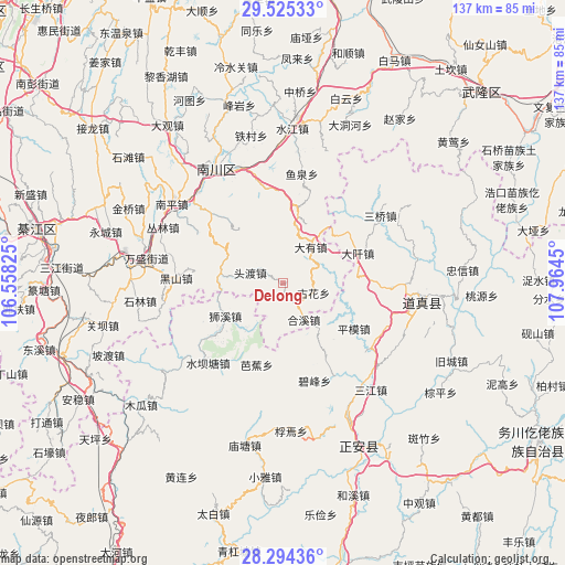
Delong GPS coordinates[2]
28° 54' 42.012" North, 107° 15' 40.932" East
| Map corner | latitude | longitude |
|---|---|---|
| Upper-left | 29.52533°, | 106.55825° |
| Center: | 28.91167°, | 107.26137° |
| Lower-right: | 28.29436°, | 107.9645° |
| Map W x H: | 136.9×136.9 km | = 85.1×85.1mi |
| max Lat: | 53.31946° ⇑66.2% North |
| Delong: | 28.91167° |
| min Lat: | ⇓33.8% South 18.22056° |
| min Long | Delong | max Long |
| 75.07348° | 107.26137° | 134.28917° |
| W 17.1%⇐ | ⇒82.9% E |
Elevation
Elevation of Delong is 1272 m = 4173 ft, and this is 787.2 m = 2583 ft above average elevation for this country.
| Max E: |
5622 m = 18445 ft | 11% |
| Delong | 1272 m 4173 ft | |
| Avg. | 484.8 m = 1591 ft | |
Min E: |
-3 m = -10 ft | 89% |
See also: China elevation on elevation.city.
Geographical zone
Delong is located in North temperate zone (between Tropic of Cancer and the Arctic Circle). Distance of this Northern Tropic circle is 608.8 km =378.3 mi to South.| Distance of | km | miles | from Delong |
|---|---|---|---|
| North Pole | 6792.4 | 4220.6 | to North |
| Arctic Circle | 4186.5 | 2601.4 | to North |
| Tropic Cancer | 608.8 | 378.3 | to South |
| Equator | 3214.7 | 1997.5 | to South |


Nearby cities:
15 places around Delong: (largest is in red/bold)
• Bajiao
20.9 km =13 mi,  197°
197°
• Bifeng
25 km =15.5 mi,  162°
162°
• Daqian
19.5 km =12.1 mi,  68°
68°
• Dayou
10.9 km =6.8 mi,  37°
37°
• Guhua
7.6 km =4.7 mi,  108°
108°
• Hexi
10.3 km =6.4 mi,  150°
150°
• Jinshan
15.4 km =9.6 mi,  277°
277°
• Pingmu
20.1 km =12.5 mi,  118°
118°
• Qingyuan
10.2 km =6.3 mi, 65°
• Sanquan
25.2 km =15.7 mi,  347°
347°
• Shixi
16.2 km =10.1 mi,  240°
240°
• Shuibatang
26.6 km =16.5 mi,  223°
223°
• Toudu
8.2 km =5.1 mi,  290°
290°
• Xinzhou
14.4 km =8.9 mi,  141°
141°
• Yangxing
25.5 km =15.8 mi, 151°
Sources, notices
• [Note1] Compared only with cities in China existing in our database
• [Src1] Map data: © OpenStreetMap contributors (CC-BY-SA)
• [Src2] Other city data from geonames.org with taken over terms of usage.
• [Src3] Geographical zone / Annual Mean Temperature by Robert A. Rohde @ Wikipedia
