Shixi geodata
Shixi (Guizhou) is a seat of a fourth-order administrative division; located in China in Asia/Shanghai (GMT+8) time zone. In our database, there are 1268 cities with bigger population. Compared to other cities in China, 66.9% of cities are located further ↑North; 83.3% of cities are located further →East and 79.3% of cities have lower elevation than Shixi. Note1


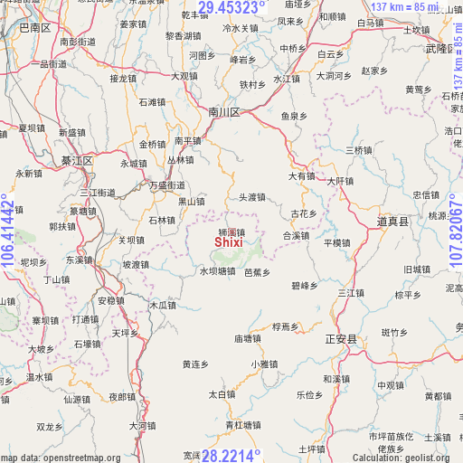
Shixi GPS coordinates[2]
28° 50' 20.904" North, 107° 7' 3.144" East
| Map corner | latitude | longitude |
|---|---|---|
| Upper-left | 29.45323°, | 106.41442° |
| Center: | 28.83914°, | 107.11754° |
| Lower-right: | 28.2214°, | 107.82067° |
| Map W x H: | 137×137 km | = 85.1×85.1mi |
| max Lat: | 53.31946° ⇑66.9% North |
| Shixi: | 28.83914° |
| min Lat: | ⇓33.1% South 18.22056° |
| min Long | Shixi | max Long |
| 75.07348° | 107.11754° | 134.28917° |
| W 16.7%⇐ | ⇒83.3% E |
Elevation
Elevation of Shixi is 661 m = 2169 ft, and this is 176.2 m = 578 ft above average elevation for this country.
| Max E: |
5622 m = 18445 ft | 20.7% |
| Shixi | 661 m 2169 ft | |
| Avg. | 484.8 m = 1591 ft | |
Min E: |
-3 m = -10 ft | 79.3% |
See also: China elevation on elevation.city.
Geographical zone
Shixi is located in North temperate zone (between Tropic of Cancer and the Arctic Circle). Distance of this Northern Tropic circle is 600.7 km =373.3 mi to South.| Distance of | km | miles | from Shixi |
|---|---|---|---|
| North Pole | 6800.5 | 4225.6 | to North |
| Arctic Circle | 4194.6 | 2606.4 | to North |
| Tropic Cancer | 600.7 | 373.3 | to South |
| Equator | 3206.6 | 1992.5 | to South |


Nearby cities:
15 places around Shixi: (largest is in red/bold)
• Bajiao
14 km =8.7 mi,  147°
147°
• Conglin
25.6 km =15.9 mi,  326°
326°
• Dayou
26.6 km =16.5 mi,  51°
51°
• Delong
16.2 km =10.1 mi,  60°
60°
• Guhua
22 km =13.7 mi,  75°
75°
• Hexi
19.1 km =11.9 mi,  92°
92°
• Jinshan
10.3 km =6.4 mi,  352°
352°
• Nantong
26.2 km =16.3 mi,  292°
292°
• Qingyuan
26.4 km =16.4 mi, 62°
• Shilin
21.4 km =13.3 mi,  281°
281°
• Shuibatang
12.1 km =7.5 mi,  200°
200°
• Toudu
12.6 km =7.8 mi,  29°
29°
• Wansheng
23 km =14.3 mi,  306°
306°
• Xinzhou
23.1 km =14.4 mi,  97°
97°
• Yangdeng
20.5 km =12.7 mi,  228°
228°
Sources, notices
• [Note1] Compared only with cities in China existing in our database
• [Src1] Map data: © OpenStreetMap contributors (CC-BY-SA)
• [Src2] Other city data from geonames.org with taken over terms of usage.
• [Src3] Geographical zone / Annual Mean Temperature by Robert A. Rohde @ Wikipedia
