Shuibatang geodata
Shuibatang (Guizhou) is a seat of a fourth-order administrative division; located in China in Asia/Shanghai (GMT+8) time zone. In our database, there are 1268 cities with bigger population. Compared to other cities in China, 67.6% of cities are located further ↑North; 83.4% of cities are located further →East and 72.2% of cities have lower elevation than Shuibatang. Note1


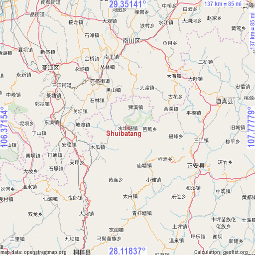
Shuibatang GPS coordinates[2]
28° 44' 12.156" North, 107° 4' 28.776" East
| Map corner | latitude | longitude |
|---|---|---|
| Upper-left | 29.35141°, | 106.37154° |
| Center: | 28.73671°, | 107.07466° |
| Lower-right: | 28.11837°, | 107.77779° |
| Map W x H: | 137.1×137.1 km | = 85.2×85.2mi |
| max Lat: | 53.31946° ⇑67.6% North |
| Shuibatang: | 28.73671° |
| min Lat: | ⇓32.4% South 18.22056° |
| min Long | Shuibatang | max Long |
| 75.07348° | 107.07466° | 134.28917° |
| W 16.6%⇐ | ⇒83.4% E |
Elevation
Elevation of Shuibatang is 459 m = 1506 ft, and this is 25.8 m = 85 ft below average elevation for this country.
| Max E: |
5622 m = 18445 ft | 27.8% |
| Avg. | 484.8 m = 1591 ft | |
| Shuibatang | 459 m = 1506 ft | |
Min E: |
-3 m = -10 ft | 72.2% |
See also: China elevation on elevation.city.
Geographical zone
Shuibatang is located in North temperate zone (between Tropic of Cancer and the Arctic Circle). Distance of this Northern Tropic circle is 589.3 km =366.2 mi to South.| Distance of | km | miles | from Shuibatang |
|---|---|---|---|
| North Pole | 6811.8 | 4232.7 | to North |
| Arctic Circle | 4206 | 2613.5 | to North |
| Tropic Cancer | 589.3 | 366.2 | to South |
| Equator | 3195.2 | 1985.4 | to South |


Nearby cities:
15 places around Shuibatang: (largest is in red/bold)
• Bajiao
11.8 km =7.3 mi,  92°
92°
• Bifeng
26.2 km =16.3 mi,  99°
99°
• Delong
26.6 km =16.5 mi,  43°
43°
• Guanba
27.2 km =16.9 mi,  285°
285°
• Hexi
25.5 km =15.8 mi,  65°
65°
• Huanglian
28.4 km =17.6 mi,  193°
193°
• Jinshan
21.8 km =13.5 mi,  7°
7°
• Miaotang
21.8 km =13.5 mi,  155°
155°
• Podu
24.3 km =15.1 mi,  274°
274°
• Shilin
22.9 km =14.2 mi,  312°
312°
• Shixi
12.1 km =7.5 mi,  20°
20°
• Toudu
24.7 km =15.3 mi,  25°
25°
• Wansheng
28.9 km =18 mi,  330°
330°
• Xinzhou
28.3 km =17.6 mi, 73°
• Yangdeng
11.4 km =7.1 mi,  259°
259°
Sources, notices
• [Note1] Compared only with cities in China existing in our database
• [Src1] Map data: © OpenStreetMap contributors (CC-BY-SA)
• [Src2] Other city data from geonames.org with taken over terms of usage.
• [Src3] Geographical zone / Annual Mean Temperature by Robert A. Rohde @ Wikipedia
