Fenshui geodata
Fenshui (Guizhou) is a seat of a fourth-order administrative division; located in China in Asia/Shanghai (GMT+8) time zone. In our database, there are 1268 cities with bigger population. Compared to other cities in China, 66.5% of cities are located further ↑North; 80.7% of cities are located further →East and 86.5% of cities have lower elevation than Fenshui. Note1


Fenshui GPS coordinates[2]
28° 52' 55.236" North, 107° 57' 16.524" East
| Map corner | latitude | longitude |
|---|---|---|
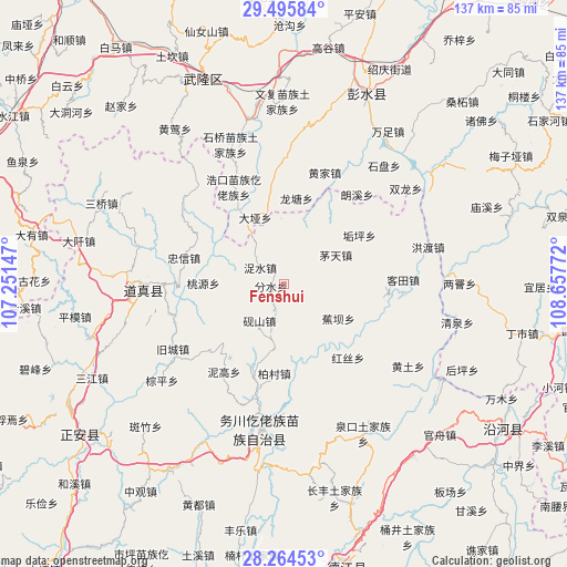
| Upper-left | 29.49584°, | 107.25147° |
| Center: | 28.88201°, | 107.95459° |
| Lower-right: | 28.26453°, | 108.65772° |
| Map W x H: | 136.9×136.9 km | = 85.1×85.1mi |
| max Lat: | 53.31946° ⇑66.5% North |
| Fenshui: | 28.88201° |
| min Lat: | ⇓33.5% South 18.22056° |
| min Long | Fenshui | max Long |
| 75.07348° | 107.95459° | 134.28917° |
| W 19.3%⇐ | ⇒80.7% E |
Elevation
Elevation of Fenshui is 1080 m = 3543 ft, and this is 595.2 m = 1953 ft above average elevation for this country.
| Max E: |
5622 m = 18445 ft | 13.5% |
| Fenshui | 1080 m 3543 ft | |
| Avg. | 484.8 m = 1591 ft | |
Min E: |
-3 m = -10 ft | 86.5% |
See also: China elevation on elevation.city.
Geographical zone
Fenshui is located in North temperate zone (between Tropic of Cancer and the Arctic Circle). Distance of this Northern Tropic circle is 605.5 km =376.2 mi to South.| Distance of | km | miles | from Fenshui |
|---|---|---|---|
| North Pole | 6795.7 | 4222.7 | to North |
| Arctic Circle | 4189.8 | 2603.4 | to North |
| Tropic Cancer | 605.5 | 376.2 | to South |
| Equator | 3211.4 | 1995.5 | to South |


Nearby cities:
15 places around Fenshui: (largest is in red/bold)
• Baicun
21.7 km =13.5 mi,  185°
185°
• Daya
17.3 km =10.7 mi,  337°
337°
• Gouping
21.8 km =13.5 mi,  57°
57°
• Haokou
26.3 km =16.3 mi,  332°
332°
• Hongsi
23.6 km =14.7 mi,  138°
138°
• Jiaoba
15.7 km =9.8 mi,  122°
122°
• Longtang
20.9 km =13 mi,  8°
8°
• Maotian
14.5 km =9 mi, 60°
• Nigao
25.6 km =15.9 mi,  214°
214°
• Runxi
22.3 km =13.9 mi,  350°
350°
• Taoyuan
19.3 km =12 mi,  270°
270°
• Yanshan
10.6 km =6.6 mi, 213°
• Zhennan
21.6 km =13.4 mi,  201°
201°
• Zhongxin
24.4 km =15.2 mi,  283°
283°
• Zhuoshui
6.9 km =4.3 mi,  305°
305°
Sources, notices
• [Note1] Compared only with cities in China existing in our database
• [Src1] Map data: © OpenStreetMap contributors (CC-BY-SA)
• [Src2] Other city data from geonames.org with taken over terms of usage.
• [Src3] Geographical zone / Annual Mean Temperature by Robert A. Rohde @ Wikipedia
