Longtang geodata
Longtang (Chongqing) is a seat of a fourth-order administrative division; located in China in Asia/Shanghai (GMT+8) time zone. In our database, there are 1268 cities with bigger population. Compared to other cities in China, 64.6% of cities are located further ↑North; 80.6% of cities are located further →East and 81.5% of cities have lower elevation than Longtang. Note1


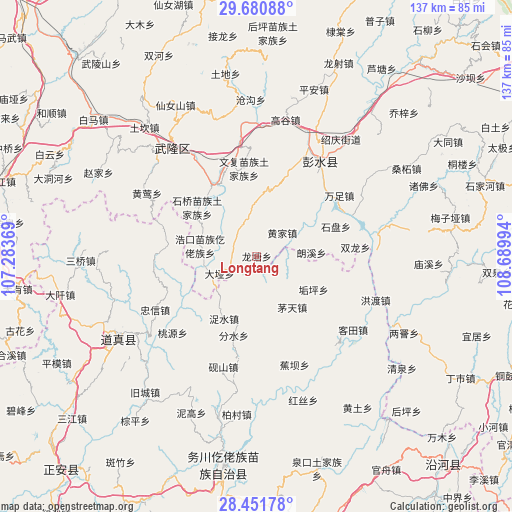
Longtang GPS coordinates[2]
29° 4' 5.376" North, 107° 59' 12.516" East
| Map corner | latitude | longitude |
|---|---|---|
| Upper-left | 29.68088°, | 107.28369° |
| Center: | 29.06816°, | 107.98681° |
| Lower-right: | 28.45178°, | 108.68994° |
| Map W x H: | 136.7×136.7 km | = 84.9×84.9mi |
| max Lat: | 53.31946° ⇑64.6% North |
| Longtang: | 29.06816° |
| min Lat: | ⇓35.4% South 18.22056° |
| min Long | Longtang | max Long |
| 75.07348° | 107.98681° | 134.28917° |
| W 19.4%⇐ | ⇒80.6% E |
Elevation
Elevation of Longtang is 767 m = 2516 ft, and this is 282.2 m = 926 ft above average elevation for this country.
| Max E: |
5622 m = 18445 ft | 18.5% |
| Longtang | 767 m 2516 ft | |
| Avg. | 484.8 m = 1591 ft | |
Min E: |
-3 m = -10 ft | 81.5% |
See also: China elevation on elevation.city.
Geographical zone
Longtang is located in North temperate zone (between Tropic of Cancer and the Arctic Circle). Distance of this Northern Tropic circle is 626.2 km =389.1 mi to South.| Distance of | km | miles | from Longtang |
|---|---|---|---|
| North Pole | 6775 | 4209.8 | to North |
| Arctic Circle | 4169.1 | 2590.6 | to North |
| Tropic Cancer | 626.2 | 389.1 | to South |
| Equator | 3232.1 | 2008.3 | to South |


Nearby cities:
15 places around Longtang: (largest is in red/bold)
• Daya
10.9 km =6.8 mi,  244°
244°
• Dianshui
25.9 km =16.1 mi,  22°
22°
• Fenshui
20.9 km =13 mi,  188°
188°
• Gouping
17.6 km =10.9 mi,  120°
120°
• Haokou
15.4 km =9.6 mi,  280°
280°
• Huangjia
9.2 km =5.7 mi,  47°
47°
• Jiangkou
22.1 km =13.7 mi,  331°
331°
• Langxi
14.7 km =9.1 mi,  88°
88°
• Maotian
16.6 km =10.3 mi,  145°
145°
• Runxi
6.8 km =4.2 mi, 280°
• Shipan
22.5 km =14 mi,  69°
69°
• Shiqiao
21.1 km =13.1 mi,  313°
313°
• Tangba
24.9 km =15.5 mi,  106°
106°
• Wenfu
23.7 km =14.7 mi,  351°
351°
• Zhuoshui
18.8 km =11.7 mi,  207°
207°
Sources, notices
• [Note1] Compared only with cities in China existing in our database
• [Src1] Map data: © OpenStreetMap contributors (CC-BY-SA)
• [Src2] Other city data from geonames.org with taken over terms of usage.
• [Src3] Geographical zone / Annual Mean Temperature by Robert A. Rohde @ Wikipedia
